
Thanksgiving Weekend Weather Outlook: Cold Air to Sweep Into the Western U.S., Bringing Possible Lowland Snow and Chilly Temperatures
UNITED STATES — A significant weather pattern shift is expected to unfold Thanksgiving weekend, as meteorologists track a surge of cold Arctic air moving into the Western United States. The setup could bring the coldest temperatures of the season and even the potential for lowland snow across parts of the Pacific Northwest and Intermountain West.
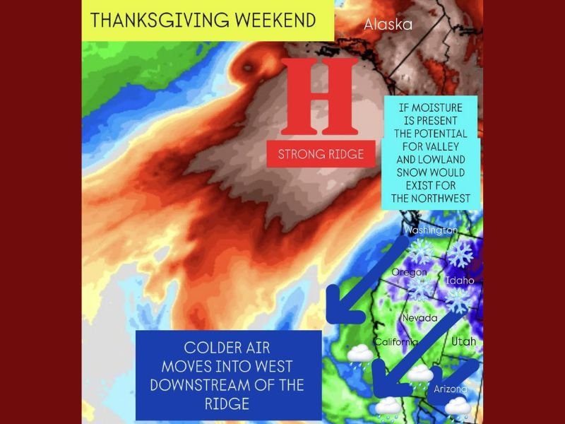
Cold Air Driven by a Strong Ridge Over Alaska
A powerful high-pressure ridge is forecast to build over the northeast Pacific and Alaska, redirecting Arctic air southward into the western U.S. This atmospheric setup will force cold air down the eastern side of the ridge, delivering a sharp temperature drop across Washington, Oregon, Idaho, Nevada, and Northern California.
Forecasters say this pattern will “lock in” cold air through the weekend, possibly producing the first widespread low-elevation snow of the season if enough moisture is available.
“This ridge is classic for ushering Arctic air into the West,” forecasters explained. “It’s the kind of setup that can trigger valley snow across the Northwest and early winter-like conditions through the Rockies.”
Lowland Snow Possible — If Moisture Aligns
While the cold air mass will be in place, snowfall chances depend heavily on moisture availability. The current forecast suggests a north-to-south flow that may limit precipitation in the Pacific Northwest, making snow uncertain in drier regions.
However, areas in the Cascades, Blue Mountains, and Northern Great Basin could see snow showers if moisture aligns with the advancing cold front. Meteorologists caution that even light snow in low-lying valleys is possible if temperatures continue to drop as models indicate.
Storm System May Develop in the Southwest
Toward the southern edge of the ridge, the forecast hints at a potential storm system spinning up across the Southwest, particularly over Arizona and Southern California. This could increase rain chances heading into the weekend after Thanksgiving, with moisture returning to parts of the desert region and Southern Plains.
The National Weather Service notes that if this low-pressure system materializes, it could bring showers and isolated thunderstorms to Arizona, Utah, and parts of Nevada — a pattern often associated with cooler, unsettled post-holiday weather.
Chilly Holiday Travel Ahead
For travelers, colder-than-average temperatures will be the dominant theme. The Pacific Northwest and Intermountain West could see morning lows dropping below freezing, while daytime highs may struggle to reach the 40s in several cities.
In contrast, much of California’s Central Valley and the Southwest will remain milder but still several degrees cooler than seasonal norms.
What to Expect
- Coldest air of the season for much of the West
- Possible lowland snow in Washington, Oregon, Idaho, and Nevada
- Rain chances increasing in Arizona and Southern California by late weekend
- Travel delays possible in mountain passes if snow develops
Meteorologists will continue monitoring how much moisture overlaps with the incoming cold air. If both align, the Thanksgiving weekend could mark the first significant winter event of the season for much of the Western U.S.
Stay tuned to NapervilleLocal.com for continuing weather updates and regional travel advisories throughout the holiday weekend.

I’ve lived in Naperville long enough to see how quickly our community changes — from new developments downtown to sudden shifts in our Midwest weather. Reporting on Naperville news and daily forecasts gives me the chance to keep neighbors informed about what really matters. My goal is simple: deliver clear, timely updates so you always know what’s happening in our city and what to expect from the skies above.