
This Morning Into Week Ahead: Rain Continues Across Alabama Before Clearing North to South With Cooler 60s Today, Chilly 40s Nights, and Warmer 80s Returning By Next Weekend
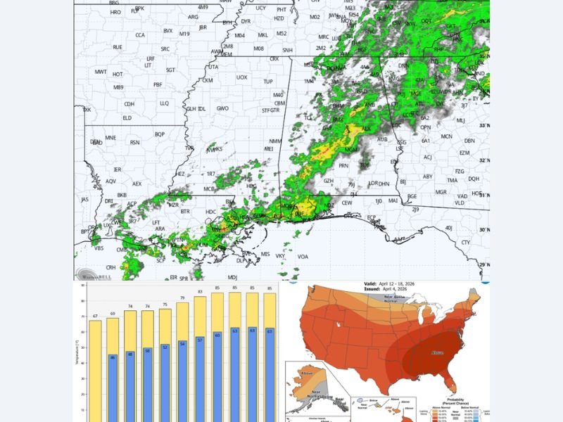
ALABAMA — A wet Easter morning is unfolding across much of the state, with rain continuing to fall across central and southern areas while northern regions begin to see gradual improvement. This system will steadily move out from north to south over the next several hours, leading to clearing skies later today. Behind the rain, noticeably cooler air will settle in, keeping afternoon temperatures in the 60s across northern counties and bringing a refreshing but cooler feel compared to recent days.
Rain Gradually Ends From North to South Today
Rain will continue through the morning hours, especially across central and southern Alabama, before gradually tapering off as the system pushes southward. Northern parts of the state will begin drying out first, followed by central and southern areas later in the day.
By the afternoon, most locations should see improving conditions, though some lingering clouds may remain.
Cooler Air Settles In With Breezy Feel
As the rain exits, cooler and drier air will move into Alabama, leading to afternoon highs mainly in the 60s across northern sections. The cooler air mass will make conditions feel more like early spring again after recent warmth. Cloud cover and a light breeze will help keep temperatures from rising much through the day.
Chilly Nights Ahead With Lows in the 40s and 50s
Clearer skies tonight will allow temperatures to drop into the 40s and 50s across the state. While it will feel cool, especially overnight and early morning, no frost is expected. These cooler nights will continue through the early part of the week, bringing crisp mornings across Alabama.
Dry and Pleasant Pattern Builds Through the Week
Looking ahead, a much drier pattern is expected to take hold. The upcoming week will feature pleasant days with highs mostly in the 70s and cool nights in the 40s and 50s.
This stretch of dry weather will provide a break from recent rain, with stable conditions dominating through midweek.
Warm-Up Returns by Next Weekend With No Freeze Threat
By the end of the week, temperatures will begin to climb again, with highs returning to the 80s by next weekend. The overall pattern suggests warmer and unusually dry conditions will continue through mid-April.
With this setup, the risk of any late-season frost or freeze appears very low, signaling a stable transition deeper into spring. Stay with NapervilleLocal.com for the latest weather updates and local forecast coverage.

I’ve lived in Naperville long enough to see how quickly our community changes — from new developments downtown to sudden shifts in our Midwest weather. Reporting on Naperville news and daily forecasts gives me the chance to keep neighbors informed about what really matters. My goal is simple: deliver clear, timely updates so you always know what’s happening in our city and what to expect from the skies above.