
This Week: Lingering Easter Front Brings Multiple Rounds of Rain Across Florida With Midweek Totals Climbing 2 to 4 Inches and Heavier Bands Targeting the East Coast Before Dry Weekend Return
FLORIDA — A wetter and more prolonged rain pattern is setting up across the state this week as a stalled frontal boundary lingers over the peninsula, bringing repeated rounds of showers and thunderstorms through midweek. Instead of a single storm event, Florida will see waves of rain spread across different regions at different times, allowing totals to gradually build. Some areas, particularly along the eastern side of the state, are expected to see significant rainfall accumulation before conditions begin to improve heading into the weekend.
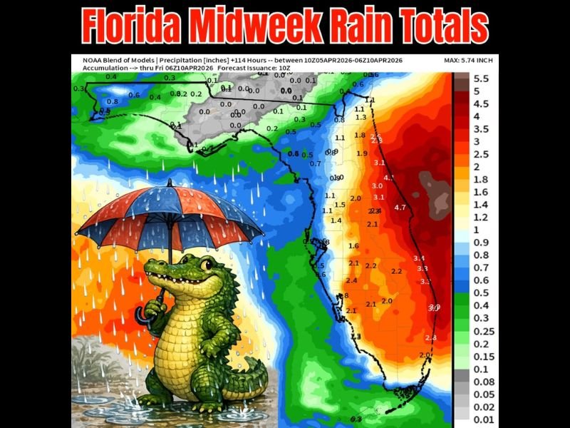
Lingering Front Keeps Rain Chances Elevated Through Midweek
An Easter-time frontal boundary is expected to flatten and stall across Florida, creating a prolonged period of unsettled weather. This setup favors multiple rounds of rain rather than one continuous event.
Periods of dry weather will still occur between waves, but the repeated development of showers and storms will allow rainfall totals to steadily increase through the middle of the week.
Highest Rain Totals Expected Along Florida’s East Coast
Forecast data indicates the heaviest rainfall will focus along eastern Florida, where totals are expected to reach between 2 to 4 inches, with some localized areas possibly exceeding those amounts.
These regions are more likely to experience persistent rain bands and stronger storm development as moisture continues to feed into the stalled boundary.
Lower Totals Expected Across Western Florida
Western portions of the state will still see rain, but totals will generally be lower, ranging from around 0.5 to 1.5 inches. Showers here are expected to be more scattered and less intense compared to the east. This sharp contrast highlights how the positioning of the front will influence rainfall distribution across Florida.
Rain Moves Out by Friday With Dry Weekend Ahead
By Friday, the lingering system is expected to weaken and move away, allowing drier conditions to return across the state. Rain chances will decrease significantly heading into the weekend.
This shift will bring a return to more typical spring weather, with fewer interruptions from rain after a midweek stretch of unsettled conditions. Stay with NapervilleLocal.com for the latest weather updates and local forecast coverage.

I’ve lived in Naperville long enough to see how quickly our community changes — from new developments downtown to sudden shifts in our Midwest weather. Reporting on Naperville news and daily forecasts gives me the chance to keep neighbors informed about what really matters. My goal is simple: deliver clear, timely updates so you always know what’s happening in our city and what to expect from the skies above.