
This Week Outlook: Colorado, Wyoming and Nebraska See Mild 60s–70s Temperatures With Daily Hit-or-Miss Showers, Gusty Winds and Increasing Rain Chances Into Next Weekend
UNITED STATES — A developing and increasingly active weather pattern is setting up across parts of Colorado, Wyoming, and Nebraska, bringing a mix of mild spring temperatures, gusty winds, and scattered afternoon showers throughout the week. While no single day looks like a washout, the overall trend points toward changing conditions each day with growing precipitation chances heading into next weekend.
Mild Temperatures With A Spring-Like Feel
Across much of the region, temperatures will remain relatively comfortable for early April. Many lower elevation areas are expected to stay in the 60s to near 70 degrees, while slightly cooler readings are expected in higher elevations and along certain corridors.
This balance of mild air and incoming systems will help create an unsettled pattern rather than extreme conditions.
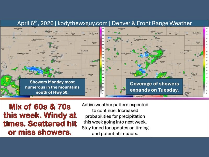
Daily Shower Chances, But Not Constant Rain
The key theme this week will be scattered, hit-or-miss afternoon showers. These will vary in coverage each day, meaning:
- Some locations may stay completely dry
- Others could see brief, passing showers
- Mountain areas will see the most consistent activity
Early in the week, the best chances for showers will be in the mountains, especially south of Highway 50 and along the Continental Divide. Lower elevations, including urban corridors, may only see isolated activity.
Winds Becoming a Noticeable Factor
Wind will also play a major role, particularly as a front strengthens and moves south across the region.
- North of the front: Easterly winds around 5–15 mph, gusting up to 25–35 mph
- South of the front (southern Colorado): Southerly winds 15–25 mph with gusts near 35 mph
The strongest winds are expected during the afternoon and evening hours, especially between 2 PM and 10 PM, which could impact travel and outdoor plans.
Midweek System Brings More Activity
By Tuesday and Wednesday, the pattern becomes a bit more active:
- Shower coverage expands slightly Tuesday, with a few thunderstorms possible
- Higher elevations could see snow above 10,000 to 11,000 feet
- A fast-moving cold front midweek may trigger additional scattered showers
Even with these changes, widespread heavy rain is not expected for most areas.
Looking Ahead: Increasing Moisture Toward The Weekend
As the week progresses, moisture from the south and southwest begins to increase, keeping daily shower chances in the forecast and potentially raising rainfall totals heading into the weekend and early next week.
At the same time, a cold Canadian system moving through the northern Plains could influence how far south cooler air and precipitation extend. There is still uncertainty about how much impact this system will have locally.
What This Means For Residents
Overall, this will be a typical active spring pattern:
- Temperatures remain mild and comfortable
- Showers are scattered and inconsistent
- Winds may be strong at times
- Conditions will change day to day
While no major severe weather is expected, the combination of wind and shifting shower coverage means staying updated will be important.
Bottom Line
A mild but unsettled week is ahead across Colorado, Wyoming, and Nebraska, featuring 60s to 70s temperatures, gusty winds, and scattered afternoon showers—along with increasing chances for more widespread precipitation heading into next weekend. Stay with NapervilleLocal.com for continuing updates as this evolving spring pattern develops.

I’ve lived in Naperville long enough to see how quickly our community changes — from new developments downtown to sudden shifts in our Midwest weather. Reporting on Naperville news and daily forecasts gives me the chance to keep neighbors informed about what really matters. My goal is simple: deliver clear, timely updates so you always know what’s happening in our city and what to expect from the skies above.