
This Weekend Into Next Week: Texas Faces Daily Storm Chances With Multiple Rounds of Severe Weather and Increasing Rain Coverage Through April 15
TEXAS — An active and unsettled weather pattern is expected to take hold starting this weekend and continuing into next week, bringing repeated chances for showers and thunderstorms across much of the state, with some storms turning severe and producing heavy rain, strong winds, and hail.
Quiet and Warm Conditions Before Pattern Shifts
Today remains relatively calm and warm, with temperatures reaching into the low 80s across many areas. However, this quieter weather will be short-lived as moisture begins increasing ahead of a more active pattern setting up across the region.
Friday Brings Increasing Rain Chances
Rain chances begin to return on Friday, with 20% to 30% coverage expected as a disturbance moves in from South Texas. Higher coverage is likely across South and Central Texas, while other areas may see more scattered activity.
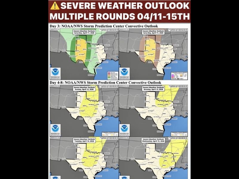
Saturday Severe Storms Develop in West Texas
By Saturday, the dryline becomes active across far West Texas, triggering thunderstorms during the afternoon and evening hours.
Some of these storms could become severe, with threats including large hail and damaging winds, before moving east and gradually weakening overnight into North Texas.
Sunday Features Two Rounds of Storms
Sunday is expected to bring a more complex setup with two separate rounds of storm activity. The first round arrives during the morning from West Texas, followed by a stronger round developing late afternoon into Sunday night, with increased potential for severe weather.
However, some parts of North Texas may see limited rainfall during the daytime hours before the stronger evening activity arrives.
Daily Storm Chances Continue Into Next Week
The active pattern continues into next week, with daily chances for showers and thunderstorms expected across the state. Each day will need to be monitored individually, as disturbances move through and influence storm development across different regions.
Increasing Moisture Supports Ongoing Storm Activity
As southwest flow strengthens and multiple disturbances move through, moisture levels will continue to rise, supporting ongoing storm development.
This setup favors repeated rounds of rain, which could lead to beneficial rainfall but also localized heavy downpours in some areas. Stay with NapervilleLocal.com for the latest weather updates and local forecast coverage.

I’ve lived in Naperville long enough to see how quickly our community changes — from new developments downtown to sudden shifts in our Midwest weather. Reporting on Naperville news and daily forecasts gives me the chance to keep neighbors informed about what really matters. My goal is simple: deliver clear, timely updates so you always know what’s happening in our city and what to expect from the skies above.