
This Weekend Through Midweek: Texas, Oklahoma, Kansas, Missouri, Arkansas, Iowa, and Illinois Face Multi-Day Severe Storm Threat With Tornadoes, 70 MPH Winds, and Large Hail
UNITED STATES — A prolonged and potentially dangerous severe weather pattern is expected to unfold from Saturday through Wednesday, with multiple rounds of storms targeting areas from Texas and Oklahoma into the Plains and Midwest, bringing risks of tornadoes, damaging winds, and large hail over several consecutive days.
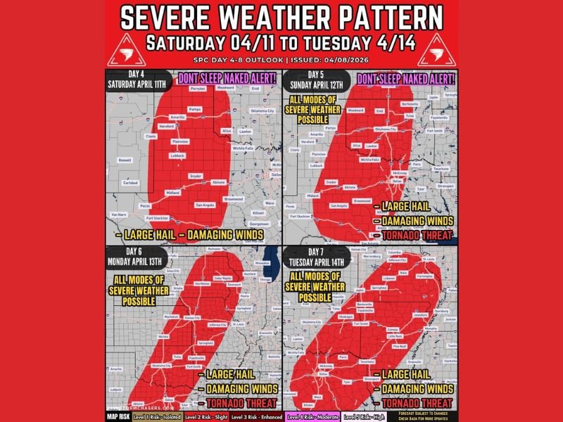
Saturday Begins With Developing Storms Across West Texas
Storms are expected to begin developing Saturday afternoon across west Texas, with scattered activity that could quickly turn severe.
Early threats include large hail and strong wind gusts, with isolated severe storms forming as conditions begin to organize.
Saturday Night Into Sunday Brings Increasing Storm Coverage
Storm activity is expected to expand Saturday night into Sunday morning, spreading across more of Texas and into Oklahoma.
By Sunday afternoon and evening, storms could become more widespread and organized, increasing the risk for damaging winds and tornadoes, especially across central and north Texas into Oklahoma.
Sunday and Monday Highlight Peak Severe Risk
The most active period appears to be Sunday into Monday, when storms are expected to organize into clusters or lines.
During this phase, all modes of severe weather are possible, including:
- Tornadoes, with increasing potential for stronger storms
- Damaging winds, possibly reaching 60 to 70+ mph
- Large hail, especially with earlier discrete storms
Storms are expected to expand northward into Kansas, Missouri, and parts of the Midwest during this time.
Monday Pushes Threat Into Midwest Including Iowa and Illinois
By Monday, the severe weather zone shifts further north, impacting areas including Iowa and Illinois.
Cities across these regions could see strong to severe storms capable of producing hail, strong winds, and isolated tornadoes as the system continues to evolve.
Tuesday Into Wednesday Keeps Pattern Active Across the South-Central U.S.
The active setup continues into Tuesday and Wednesday, with the focus shifting back south into areas including Arkansas, Missouri, and surrounding states.
Another round of organized storms is possible, again bringing threats of large hail, damaging winds, and tornado potential.
Multiple Rounds Increase Overall Risk
With several consecutive days of storms expected, the repeated nature of this pattern raises concerns for cumulative impacts, including localized flooding and repeated severe weather in the same areas.
Conditions may evolve each day, but the overall trend clearly points to an extended stretch of active and potentially dangerous weather. Stay with NapervilleLocal.com for the latest weather updates and local forecast coverage.

I’ve lived in Naperville long enough to see how quickly our community changes — from new developments downtown to sudden shifts in our Midwest weather. Reporting on Naperville news and daily forecasts gives me the chance to keep neighbors informed about what really matters. My goal is simple: deliver clear, timely updates so you always know what’s happening in our city and what to expect from the skies above.