
Three Major U.S. Regions Face Heavy Rainfall and Storm Threats Over the Next 10 Days
UNITED STATES — Meteorologists are tracking a multi-region precipitation event that could bring widespread heavy rainfall, flash flooding, and severe storms to large portions of the United States over the next 10 days.
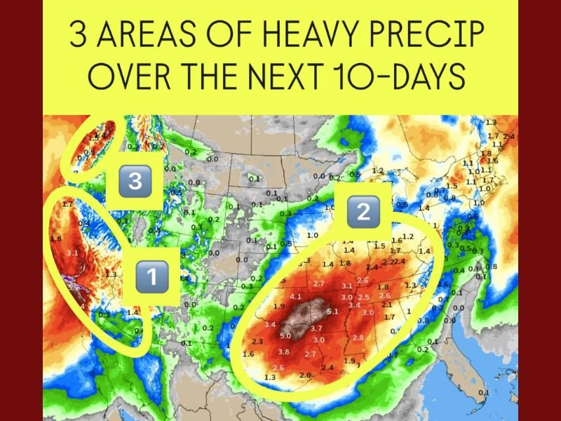
Forecast models highlight three primary zones of concern:
- California and the Desert Southwest
- The Southern Plains through the Midwest and Ohio Valley
- Western Washington and Oregon
Each region faces different threats — ranging from mountain snow and coastal flooding out west to severe thunderstorms across the central U.S.
1. California and the Desert Southwest — Flooding and Mountain Snow Expected
The first major precipitation zone covers California, Arizona, and parts of Nevada and New Mexico, where an active Pacific storm track is funneling in moisture from the ocean.
According to forecasters, Southern California and the Los Angeles Basin will see the heaviest rainfall through the upcoming weekend, with totals between 2 to 4 inches, while the Sierra Nevada and San Bernardino Mountains could receive several feet of snow.
This system will also impact Las Vegas, Phoenix, and Tucson, with forecasters warning of potential flooding in desert washes and mudslides near burn scars.
“We’re entering an atmospheric pattern capable of producing repeated rounds of rain — it’s not just one storm, but a train of systems,” meteorologists said.
Residents across Southern California and the Desert Southwest are urged to remain alert, especially as soil saturation increases and flash flood risks expand.
2. Southern Plains to the Midwest and Ohio Valley — Severe Weather Likely
The second — and potentially most impactful — precipitation zone stretches from Texas and Oklahoma through Arkansas, Missouri, Illinois, and into Ohio.
A series of storm systems developing from the Gulf of Mexico will collide with colder northern air, creating the perfect setup for severe weather outbreaks.
This region is expected to see 2 to 5 inches of rain over the next week, alongside strong thunderstorms and possible tornado activity.
Cities such as Dallas, Little Rock, St. Louis, Indianapolis, and Columbus could face periods of intense rain and gusty winds, especially between Nov. 19 and 23.
Forecasters also warn of flash flooding in low-lying areas and hail-producing storms in portions of Texas and Oklahoma.
“The combination of moisture, instability, and wind shear points toward an active storm corridor across the heart of the country,” forecasters from the Storm Prediction Center noted.
This pattern will continue to evolve into Thanksgiving week, potentially bringing another round of strong storms across the central and southeastern U.S.
3. Pacific Northwest — Continuous Rain and High-Elevation Snow
Meanwhile, the Pacific Northwest is bracing for persistent rain and mountain snow as a conveyor belt of moisture, known as an atmospheric river, moves inland.
Western Washington and Oregon, including Seattle and Portland, will likely see 2–6 inches of rainfall, while the Cascade Mountains could accumulate over 20 inches of snow in higher elevations.
This region’s flooding threat is primarily focused on river rises and mudslides along steep terrain. The rainfall will benefit regional reservoirs but may cause travel difficulties on mountain passes.
Nationwide Pattern: Storm Energy and Severe Weather Outlook
Meteorologists say the next 10 days will feature a dynamic and shifting jet stream, leading to rapid temperature changes and storm formation across multiple regions.
- West Coast: Wet conditions with heavy snow in the Sierra and Cascades.
- Central U.S.: Repeated rounds of storms and flash flooding potential.
- Midwest to Ohio Valley: Risk of severe weather transitions to cooler rain by Thanksgiving week.
“This is one of the most active patterns we’ve seen this fall,” forecasters said. “People traveling ahead of Thanksgiving should plan for potential delays due to flooding, heavy snow, and thunderstorms.”
Safety and Travel Precautions
Officials recommend:
- Monitoring local weather alerts and flood advisories.
- Avoiding travel through flooded roads or mountain passes during heavy snow.
- Preparing for potential power outages caused by wind or lightning.
- Allowing extra time for air and road travel, especially for holiday trips.
The active pattern is expected to persist into late November, with additional systems likely impacting parts of the country heading into early December.
How is your area preparing for the upcoming storms? Stay informed and share updates with your community at NapervilleLocal.com.

I’ve lived in Naperville long enough to see how quickly our community changes — from new developments downtown to sudden shifts in our Midwest weather. Reporting on Naperville news and daily forecasts gives me the chance to keep neighbors informed about what really matters. My goal is simple: deliver clear, timely updates so you always know what’s happening in our city and what to expect from the skies above.