
Three-Phase Winter Storm Forecast Signals Heavy Snow, Ice, and Travel Disruptions Across Ohio Valley, Kentucky, and West Virginia Through Monday
UNITED STATES — A complex, three-phase winter storm is taking shape across parts of the Ohio Valley, eastern Kentucky, and West Virginia, with forecasters warning that this system will be far more than just a snow event. According to the latest forecast issued January 23, the storm is expected to unfold from Saturday evening through Monday morning, bringing a dangerous mix of heavy snow, sleet, ice, and freezing rain depending on location.
Meteorologists caution that small shifts in temperature or storm track could dramatically change outcomes, pushing some communities into significantly higher snow totals or prolonged icing conditions.
Where the Heaviest Snow Is Expected
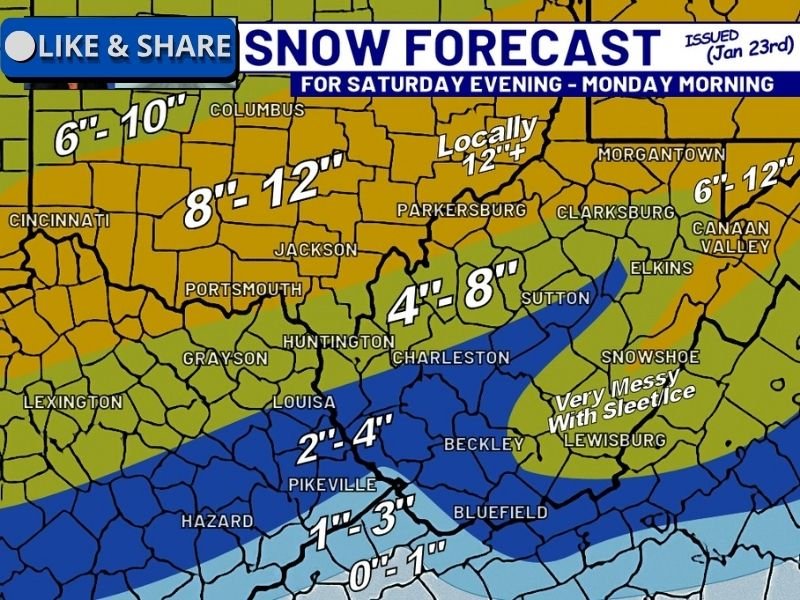
Forecast guidance shows a wide range of snowfall totals across the region, with localized jackpot zones exceeding one foot where the storm remains all snow.
Areas currently favored for higher snowfall totals include:
- Central and southern Ohio: generally 6 to 10 inches
- Southeastern Ohio into northern West Virginia: 8 to 12 inches, with localized totals above 12 inches
- Northern West Virginia (near Parkersburg and Clarksburg): locally 12 inches or more
- Eastern Kentucky into southern West Virginia: 4 to 8 inches
These totals reflect locations that stay predominantly snow through the duration of the storm.
Messy Transition Zone Brings Ice and Sleet Concerns
Not everyone will see clean snowfall. A transition zone stretching across southern West Virginia and parts of eastern Kentucky is expected to experience a very messy combination of sleet and freezing rain.
Key impacts in this zone include:
- Reduced snow totals due to mixing
- Ice accumulation that may coat untreated roads
- Increased risk of power outages if ice builds on trees and power lines
- Extremely hazardous travel conditions, especially overnight
Cities such as Beckley, Bluefield, Lewisburg, and surrounding communities fall within this higher-risk mixed-precipitation corridor.
Southern Edge Sees Lighter Snow but Bigger Freeze Risk
Along the southern fringe of the storm — including portions of far southern Kentucky — snowfall totals drop sharply, with estimates ranging from 0 to 3 inches. However, forecasters stress this does not mean impacts will be minor.
Once precipitation ends, temperatures are expected to plunge, freezing everything solid and potentially trapping untreated snow, slush, and ice in place through Tuesday morning.
Why This Storm Is Being Closely Watched
Forecasters are emphasizing that this system:
- Will evolve in three distinct phases
- Includes multiple precipitation types
- May produce rapid freeze-ups after precipitation ends
- Could leave drivers stranded if snow is not cleared early
Even areas expecting “lesser” snow totals could see significant disruption if snow and ice are allowed to compact before the deep freeze arrives.
Travel and Safety Impacts Expected
Widespread impacts are anticipated across the region, including:
- Dangerous road conditions Saturday night through Monday
- Difficult cleanup due to sleet and ice layers
- Increased risk of stranded vehicles if roads refreeze
- Possible power outages in areas with icing
Residents are urged to complete travel, clearing, and preparation efforts early, rather than waiting to see how totals trend.
Bottom Line
This is not a simple snowfall forecast. The three-phase winter storm expected this weekend has the potential to deliver heavy snow in some areas, damaging ice in others, and widespread freezing conditions that lock impacts in place well into next week.
NapervilleLocal.com will continue tracking major winter storms nationwide and explaining how evolving forecasts translate into real-world impacts. Stay with us for continued updates as this system develops and final snowfall and ice zones become clearer.

I’ve lived in Naperville long enough to see how quickly our community changes — from new developments downtown to sudden shifts in our Midwest weather. Reporting on Naperville news and daily forecasts gives me the chance to keep neighbors informed about what really matters. My goal is simple: deliver clear, timely updates so you always know what’s happening in our city and what to expect from the skies above.