
Today: Florida Sees Extreme 3 to 24 Inch Rainfall Totals Over 72 Hours as Flooding Concerns Rise Across Multiple Regions
FLORIDA — A significant rainfall event has unfolded across the state over the past three days, with newly compiled observations showing widespread heavy totals and some areas reporting over 20 inches of rain, raising concerns about localized flooding and water saturation.
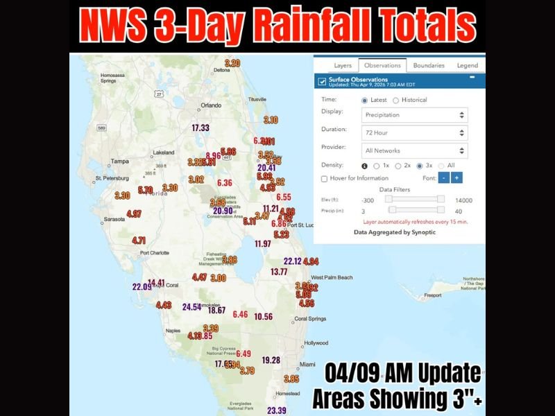
Widespread Heavy Rainfall Across the State
Recent 72-hour observations indicate that much of Florida has picked up at least 3 inches of rain, with many locations far exceeding that mark. From the Gulf Coast to the Atlantic side, consistent rainfall has created a broad zone of soaking conditions.
Areas near Tampa, Sarasota, and parts of southwest Florida recorded totals generally ranging between 3 to 6 inches, providing meaningful moisture to drought-prone regions.
Extreme Rainfall Totals Raise Eyebrows
Some of the most intense rainfall has been concentrated across central and southern Florida, where several observation points indicate double-digit totals.
- Central Florida locations reported readings such as 17.33 inches near Orlando
- East-central and southeast areas showed totals exceeding 20 inches, including readings around 20.41 inches
- Southwest Florida and inland regions recorded extreme values, including 24.54 inches and 22+ inches in localized zones
- South Florida also saw heavy totals, with readings like 19.28 inches near the Miami area
While some of the highest numbers may appear unusually large, the sheer number of elevated readings suggests that very heavy rainfall has indeed impacted multiple regions.
Benefits and Risks: Drought Relief Meets Flood Threat
This event is bringing a mixed impact across Florida.
On one hand, the rainfall is highly beneficial for drought conditions, especially as parts of the state head through a typically drier period. Soil moisture levels are improving, and water reserves are getting a much-needed boost.
On the other hand, the intensity and volume of rainfall increase the risk of:
- Localized flooding in low-lying areas
- Standing water on roadways
- Rapid rises in small streams and drainage systems
Urban areas and regions with poor drainage are particularly vulnerable after such prolonged heavy rainfall.
More Rain Still Possible
The pattern is not fully settled yet. Additional rain is expected in some of the same regions, meaning already saturated areas could see renewed flooding concerns if more heavy bands develop.
What This Means Going Forward
Florida now enters a period where ground saturation is high, making it easier for any additional rainfall to quickly lead to runoff and flooding. Even moderate rain over the next few days could have amplified impacts.
Residents across the state should remain alert, especially in areas that have already received double-digit rainfall totals, as conditions can change quickly. Stay with NapervilleLocal.com for continued weather updates and national storm coverage as patterns evolve across the country.

I’ve lived in Naperville long enough to see how quickly our community changes — from new developments downtown to sudden shifts in our Midwest weather. Reporting on Naperville news and daily forecasts gives me the chance to keep neighbors informed about what really matters. My goal is simple: deliver clear, timely updates so you always know what’s happening in our city and what to expect from the skies above.