
Today: Michigan Braces for Another Cold Day With Widespread 20s–40s Temperatures, Light Snow in the U.P. and Northern Areas, Gradual Warm-Up Expected Later This Week
MICHIGAN — Another blast of cold air is settling across the state this Monday, bringing below-normal temperatures and even some snow to parts of the region. While this isn’t expected to be a major winter event, the return of wintry conditions in early April is a sharp reminder that spring is still struggling to take hold.
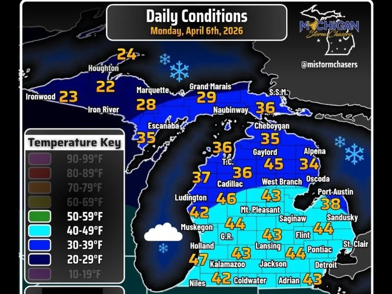
Cold Temperatures Dominate Statewide
Temperatures across Michigan today are running well below seasonal averages, with much of the state stuck in the 30s and 40s, and even colder conditions across the Upper Peninsula.
Northern areas, including the U.P., are seeing highs only in the 20s to near 30 degrees, while central and southern Michigan are generally holding in the low to mid-40s. This is a significant drop compared to recent milder days and creates a noticeably chilly feel throughout the day.
Snow Returns to Northern Michigan and the U.P.
Along with the cold air, light snow is expected across the Upper Peninsula and parts of northern Michigan. While widespread heavy accumulation is not anticipated, some areas—especially in the U.P.—could pick up a couple of inches of snow.
For most other parts of the state, any snow will be light and sporadic, with minimal to no accumulation expected.
Southern Michigan Stays Cold but Mostly Dry
In southern sections of the state, including areas around Grand Rapids, Lansing, and Detroit, conditions will remain mostly dry. However, temperatures will still struggle, generally staying in the low to mid-40s throughout the day. The combination of cloud cover and cold air will make it feel more like late winter than early April.
A Gradual Warm-Up Is Ahead
The good news is that this cold snap won’t last long. Forecast trends indicate a gradual warming pattern setting in by mid to late week, allowing temperatures to climb back toward more typical spring levels.
By the second half of the week, highs are expected to rebound, bringing a much more comfortable and seasonable feel across the state.
Bottom Line
Today’s weather across Michigan is defined by cold temperatures, light snow in northern regions, and a lingering winter-like feel. While impacts remain limited, the chilly conditions will be noticeable statewide.
Residents can look forward to improving conditions as the week progresses, with warmer temperatures returning and winter finally loosening its grip. Stay with NapervilleLocal.com for continued weather updates and regional outlooks.

I’ve lived in Naperville long enough to see how quickly our community changes — from new developments downtown to sudden shifts in our Midwest weather. Reporting on Naperville news and daily forecasts gives me the chance to keep neighbors informed about what really matters. My goal is simple: deliver clear, timely updates so you always know what’s happening in our city and what to expect from the skies above.