
Today: Rain and Snow Spread Across Massachusetts, New York, Vermont, New Hampshire, Connecticut, Rhode Island, and Maine With Travel Impacts
BOSTON, MASSACHUSETTS — A complex early morning weather system is spreading a mix of rain and snow across parts of the Northeast, with steady snowfall extending from eastern New York into Vermont and New Hampshire, while heavier rain continues along coastal Massachusetts, Rhode Island, and Connecticut, creating varied travel conditions across the region.
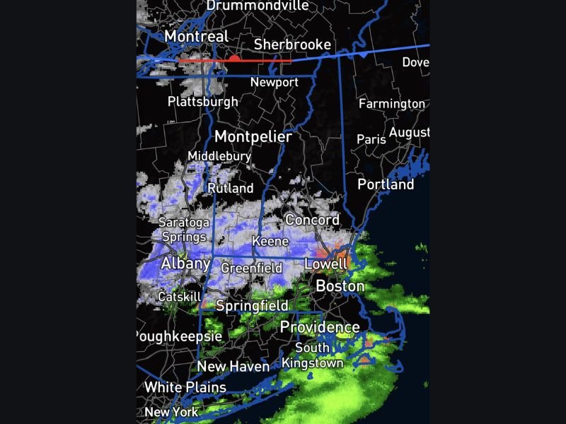
Snow Band Expands From Albany to New Hampshire
A noticeable band of snow is pushing eastward from areas near Albany through southern Vermont and into New Hampshire. Cities like Keene and areas west of Concord are seeing steady snowfall, with light to moderate accumulation ongoing.
This snow zone is fairly organized, suggesting continued coverage through the morning hours. Roads in these inland areas could become slick, especially on untreated surfaces and secondary routes.
Rain Intensifies Along Coastal Massachusetts and Rhode Island
Closer to the coast, the system is producing steady to occasionally heavier rain. Areas including Boston, Providence, and parts of southeastern Massachusetts are seeing consistent rainfall, with pockets of heavier precipitation just offshore moving inland.
The radar also shows some localized heavier bursts near Lowell and surrounding areas, indicating brief periods of reduced visibility and wet road conditions during the morning commute.
Mixed Conditions Create Travel Challenges Across the Region
The transition zone between snow and rain is creating a mixed precipitation area stretching across western Massachusetts and into parts of southern New Hampshire.
This mix can lead to slushy conditions, especially in areas where temperatures hover near freezing. Drivers traveling between inland and coastal zones may experience rapidly changing road conditions over short distances.
Northern Areas Remain Mostly Dry for Now
Regions farther north, including parts of northern Vermont, northern New Hampshire, and Maine, are currently seeing little to no precipitation on radar. However, cloud cover remains in place, and conditions could evolve later in the day depending on how the system shifts. Stay with NapervilleLocal.com for the latest weather updates and local forecast coverage.

I’ve lived in Naperville long enough to see how quickly our community changes — from new developments downtown to sudden shifts in our Midwest weather. Reporting on Naperville news and daily forecasts gives me the chance to keep neighbors informed about what really matters. My goal is simple: deliver clear, timely updates so you always know what’s happening in our city and what to expect from the skies above.