
Today Through Weekend: Alabama and Florida Stay Dry With Cool 40s–50s Mornings, Sunny 70s Days and Rising 80s Ahead, Rainfall Largely Missing in 7-Day Forecast
UNITED STATES — An unusually dry weather pattern continues across Alabama and parts of the Florida Panhandle, with little to no meaningful rainfall expected through the weekend and even into early next week. While this setup may benefit outdoor plans, it continues to raise concerns for ongoing dry conditions and lack of rainfall across the region.
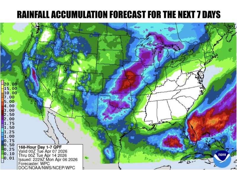
Dry Stretch Continues With Little Rain in Sight
The latest 7-day rainfall outlook highlights a clear trend: most of Alabama remains largely dry, with only minimal precipitation expected. The heaviest rainfall over the next week is projected to stay:
- Well to the north across parts of the Midwest
- Offshore and far south near Florida and the Gulf
This leaves much of Alabama in a rainfall deficit pattern, with no widespread soaking rain expected anytime soon.
Cool Mornings, Comfortable Afternoons
Despite the lack of rain, temperatures will remain fairly pleasant:
- Morning lows: 40s in eastern Alabama, 50s in western areas
- Afternoon highs: mainly in the 70s through Friday
A steady easterly breeze (10–15 mph) will keep mornings feeling cooler, especially in eastern parts of the state.
Limited Shower Chances Stay South
There is a slight exception to the dry pattern:
- Far southwest Alabama
- Florida Panhandle
These areas could see a few isolated showers, but activity is expected to remain limited and well south of most inland communities.
Warmer Weekend Ahead
As the weekend approaches, temperatures will begin to climb:
- Highs rising into the 80s
- Continued dry conditions across most areas
This warming trend combined with the lack of rainfall reinforces the extended dry stretch heading into next week.
Why This Dry Pattern Matters
While sunny weather may seem ideal, the broader concern is the lack of meaningful rainfall during a typically wetter time of year. With April normally bringing consistent precipitation, this prolonged dry period could:
- Worsen local drought conditions
- Impact soil moisture levels
- Increase fire weather concerns over time
Early Signs of Change — But Not Yet
There are early indications that a few showers could return sometime next week, possibly around Thursday. However, current signals suggest:
- No widespread or significant rainfall yet
- Continued dominance of dry conditions
Bottom Line
Alabama and nearby Gulf Coast regions are facing a prolonged dry stretch, with comfortable 70s through the week, warmer 80s this weekend, and only minimal chances for rain. While great for outdoor activities, the pattern continues to fall short in delivering much-needed precipitation. Stay with NapervilleLocal.com for continued updates as this dry weather pattern evolves.

I’ve lived in Naperville long enough to see how quickly our community changes — from new developments downtown to sudden shifts in our Midwest weather. Reporting on Naperville news and daily forecasts gives me the chance to keep neighbors informed about what really matters. My goal is simple: deliver clear, timely updates so you always know what’s happening in our city and what to expect from the skies above.