
Today Through Weekend: Colorado Sees Warm 60s and 80s With Increasing Storm Chances, Gusty Winds, and Hail Risk by Thursday and Friday
COLORADO — Warm and mostly dry conditions are expected today across much of the state, but a shift toward a more active weather pattern begins Thursday, bringing increasing chances for scattered showers and thunderstorms along with gusty winds and a growing risk of hail into the weekend.
Warm Temperatures and Limited Rain Today
Today will feature scattered clouds with little to no precipitation expected. Temperatures will climb into the 60s and 70s across northern areas, including the western slope, while locations along and south of Highway 50 could reach into the 80s. Overall, it will feel warm and comfortable, making it one of the quieter days before conditions begin to change.
Gusty Winds Develop Across Mountains and Plains
Wind will be a notable factor today, especially in the mountains, foothills, and along the I-25 corridor. Northwest winds are expected to range from 5 to 15 mph with gusts up to 25–30 mph.
Across the eastern plains, winds will shift more easterly, with speeds of 5 to 15 mph and gusts up to 25 mph, particularly later in the day.
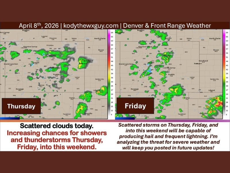
Storm Chances Increase Starting Thursday
Beginning Thursday, a shift in the weather pattern will bring increasing instability as southwest flow interacts with a frontal boundary.
This setup will support the development of scattered showers and thunderstorms Thursday and Friday, with activity expected to continue into the weekend.
Hail Risk Returns With Developing Storms
While the severe weather threat remains relatively low for now, any thunderstorm in this region has the potential to produce hail.
Colorado sits within a region often referred to as “Hail Alley,” meaning even non-severe storms can generate hail and brief heavy downpours.
Unsettled Pattern Continues Into the Weekend
The trend toward scattered storms is expected to persist through the weekend and into early next week, though coverage will remain hit-or-miss.
Some areas may receive beneficial rainfall, while others could miss out entirely, depending on how storm cells develop and track. Stay with NapervilleLocal.com for the latest weather updates and local forecast coverage.

I’ve lived in Naperville long enough to see how quickly our community changes — from new developments downtown to sudden shifts in our Midwest weather. Reporting on Naperville news and daily forecasts gives me the chance to keep neighbors informed about what really matters. My goal is simple: deliver clear, timely updates so you always know what’s happening in our city and what to expect from the skies above.