
Tonight: Heavy Rain and Flood Risk Across Illinois as Storms Continue Overnight With 2 Inches Possible
CENTRAL ILLINOIS — A shifting weather pattern is bringing a renewed round of thunderstorms overnight, with the main concern now turning toward heavy rainfall and localized flooding across the state. While the earlier tornado threat has been removed, a Flood Watch remains in effect through Saturday morning as storms continue to develop and move through the region.
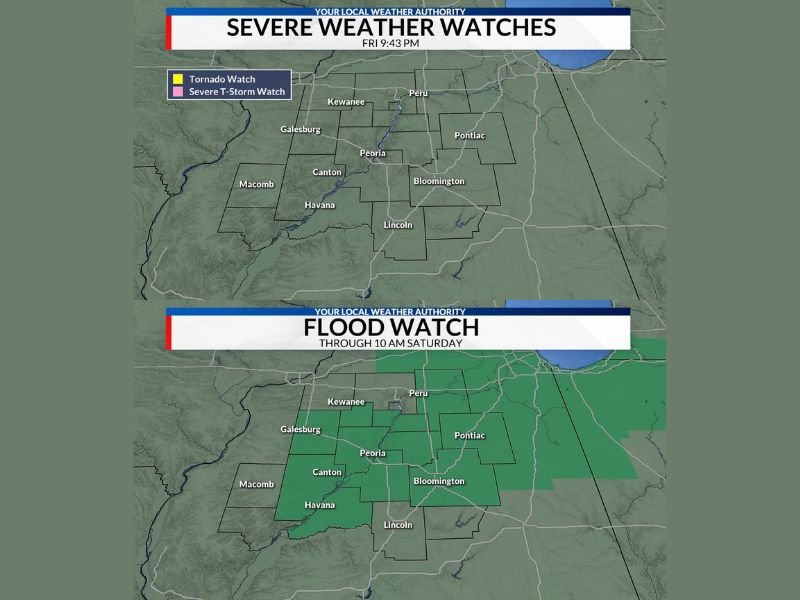
Tornado Threat Ends but Storm Activity Continues Overnight
The Tornado Watch that had been in place earlier across central Illinois has now been cancelled, signaling a lower risk for severe tornado activity. However, this does not mean conditions are completely quiet.
Additional thunderstorms are expected overnight as a cold front approaches from the west. Some storms may still produce gusty winds, with isolated wind gusts reaching up to 60 mph. Despite that, the overall severe weather risk is considered low compared to earlier concerns.
Flooding Becomes the Primary Concern Across Illinois
The biggest threat overnight has shifted to heavy rainfall and potential flooding. Storms are expected to repeatedly move over the same areas, increasing the risk of water accumulation.
Rainfall totals could reach up to an additional 2 inches in parts of central Illinois, especially in areas including Peoria, Bloomington, Pontiac, Lincoln, Galesburg, and surrounding communities. With already saturated ground in some locations, even moderate rainfall could quickly lead to localized flooding issues.
A Flood Watch remains in effect through 10 AM Saturday, covering much of central Illinois, indicating that conditions are favorable for flooding to develop.
What Residents Should Watch for Overnight
Residents across Illinois should stay alert overnight, especially in flood-prone areas. Low-lying roads, drainage systems, and urban areas could experience water buildup if heavier rain bands persist.
While the severe storm threat has decreased, the combination of steady rainfall and occasional thunderstorms could still create hazardous travel conditions by early morning. Stay with NapervilleLocal.com for the latest weather updates and local forecast coverage.

I’ve lived in Naperville long enough to see how quickly our community changes — from new developments downtown to sudden shifts in our Midwest weather. Reporting on Naperville news and daily forecasts gives me the chance to keep neighbors informed about what really matters. My goal is simple: deliver clear, timely updates so you always know what’s happening in our city and what to expect from the skies above.