
Tonight Into Saturday: Heavy Rain Targets Southern Michigan With Flooding Risk and 2 Inch Totals Expected
SOUTHERN MICHIGAN — Rain is set to become the main weather story tonight as a surge of moisture moves into the region, bringing periods of heavy rainfall through early Saturday. While the day started calm, conditions will deteriorate overnight with increasing concerns for localized flooding, especially across southern parts of the state.
Heavy Rain Develops Overnight South of I-96
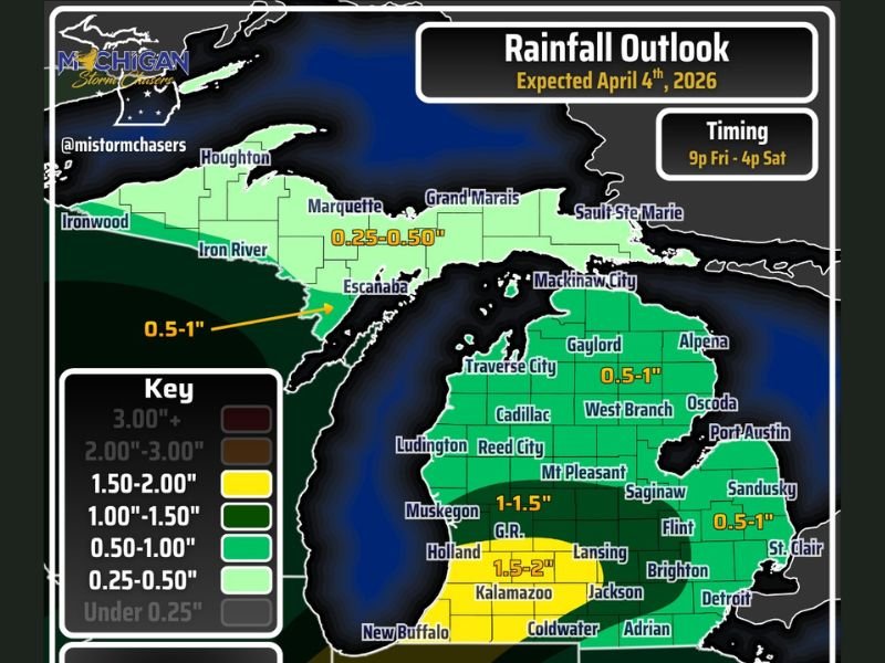
As the night progresses, widespread rain will overspread southern Michigan, particularly south of the I-96 corridor. The heaviest rainfall is expected from areas south of Grand Rapids toward Kalamazoo and Hastings, where steady downpours could lead to water buildup on roads and in low-lying areas.
Rainfall totals are expected to range between 1 to 2 inches across much of southern Michigan, with some localized areas potentially exceeding 2 inches where heavier bands persist.
Flooding Concerns Increase in Key Areas
With consistent rainfall expected overnight, minor flooding issues are likely to develop, especially in urban and poor drainage areas. Roadway ponding and minor yard flooding could become common by early Saturday morning.
Areas extending north and east toward the Tri-Cities could also see higher totals beyond the general 1 to 1.5 inch range, depending on how rain bands evolve.
Storms Remain Below Severe Limits but Still Impactful
A few embedded thunderstorms are possible, mainly south of I-94, but the overall severe weather threat remains limited. Conditions are not expected to support widespread severe storms, with wind gusts expected to stay below 60 mph and hail below 1 inch in most cases. Even without severe storms, the intensity of rainfall alone will be enough to create hazardous conditions overnight.
Rain Tapers Saturday but Showers May Linger East
Rain is expected to gradually taper off for most areas by around 4 PM Saturday. However, additional showers and thunderstorms could redevelop into the evening across eastern Michigan, including parts of the Thumb region and metro Detroit. In these areas, localized rainfall totals above 1 inch may still occur even after the main system begins to weaken.
Mixed Precipitation Possible in Upper Peninsula
Across northern Michigan and the Upper Peninsula, precipitation may fall as a mix of snow, sleet, or freezing rain, especially in areas expecting lighter totals between 0.25 and 0.50 inches.
This could create slick travel conditions in northern sections, even as southern Michigan deals with heavy rain. Stay with NapervilleLocal.com for the latest weather updates and local forecast coverage.

I’ve lived in Naperville long enough to see how quickly our community changes — from new developments downtown to sudden shifts in our Midwest weather. Reporting on Naperville news and daily forecasts gives me the chance to keep neighbors informed about what really matters. My goal is simple: deliver clear, timely updates so you always know what’s happening in our city and what to expect from the skies above.