
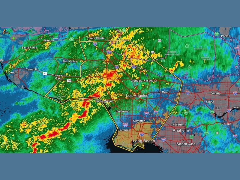
Tornado Possible as Severe Thunderstorm Warning Covers Los Angeles, Santa Monica, Pasadena and Long Beach with 70+ MPH Winds
LOS ANGELES, CALIFORNIA — A dangerous severe thunderstorm is sweeping across the Los Angeles metro area, prompting a warning that includes the possibility of a tornado and wind gusts exceeding 70 mph. Radar imagery shows a powerful line of storms pushing inland from the Pacific, with the heaviest cores stretching from near Santa Monica and Thousand Oaks through downtown Los Angeles and northeast toward Glendale and Pasadena.
Warning Area Includes Major LA Communities
The severe thunderstorm warning polygon covers a large portion of central and western Los Angeles County, including:
- Santa Monica
- Thousand Oaks
- Simi Valley
- Glendale
- Pasadena
- Downtown Los Angeles
- Inglewood
- Torrance
- Long Beach
Heavy rain bands are moving east-northeast, with intense red and orange radar returns indicating torrential rainfall and damaging wind potential.
70+ MPH Winds and Tornado Risk
The warning highlights wind gusts over 70 mph, strong enough to:
- Down trees and large branches
- Cause scattered power outages
- Damage roofs and structures
- Make travel extremely dangerous, especially on bridges and elevated roadways
Forecasters have also indicated a tornado is possible within this storm. While tornadoes in Southern California are rare compared to the Midwest, they can and do occur in strong winter storm setups when atmospheric rotation develops within embedded cells.
Residents are urged to stay away from windows and move to an interior room on the lowest floor if warnings are upgraded or rotation is confirmed.
Intense Rainfall and Flash Flood Concerns
The radar shows a solid shield of heavy rain extending from coastal areas near Oxnard and Camarillo through Santa Clarita and into the Angeles National Forest.
Localized flooding is possible in low-lying and poor-drainage areas. Urban corridors including downtown Los Angeles, El Monte, and parts of the San Fernando Valley could see rapid ponding on roads. Drivers should avoid flooded roadways and use extreme caution as visibility may drop quickly under the heaviest bands.
Storm Moving Toward Inland Empire
As the line progresses eastward, areas including Anaheim, Santa Ana, Fullerton, Chino, and Ontario will likely experience heavy rain and gusty winds next. The strongest wind potential currently appears concentrated from the coast through central Los Angeles County, but conditions can change rapidly.
What This Means Beyond California
While this event is unfolding in Southern California, severe weather this early in the year highlights how dynamic February patterns can be across the United States.
For readers in Illinois and the Midwest, including Naperville, this serves as a reminder that winter and early spring systems can produce severe weather threats even outside traditional tornado regions. For continued updates on significant national weather events and how shifting storm patterns may impact the Midwest, stay connected with NapervilleLocal.com.

Naperville is a community with stories that deserve to be told — both the serious ones about safety and justice, and the lighter ones that capture our culture and daily life. I focus on covering crime reports and court updates while also highlighting the traditions, events, and social trends that shape who we are. Through my reporting, I want to give readers a fuller picture of Naperville — the challenges we face and the character that keeps our city strong.