
Tornado Risk Returns to Tennessee, Kentucky, and Alabama on Friday, Forecasters Warn
NASHVILLE, TENNESSEE — Meteorologists are monitoring a developing storm system that could bring isolated tornadoes, strong winds, and hail to portions of the Deep South, Tennessee, and Kentucky on Friday, November 7.
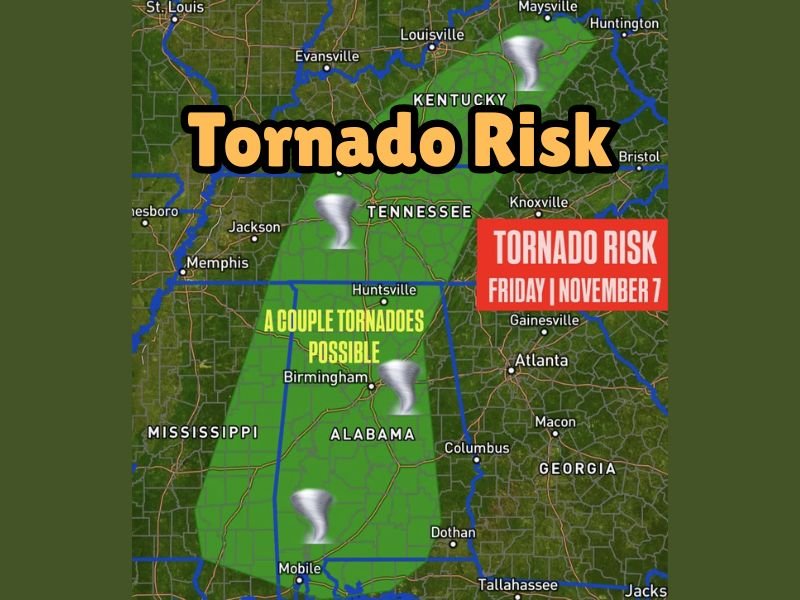
According to Meteorologist Chris Nunley, a low tornado risk will extend from southern Alabama into middle Tennessee and parts of Kentucky, as a cold front moves eastward through the region. Though the overall risk remains limited, Nunley cautioned that “a couple of tornadoes are possible”, particularly in areas where wind shear and moisture overlap.
Storm Setup and Impact Areas
Forecasters say the setup for Friday’s weather includes a mix of warm, moist Gulf air and advancing cooler air from the west, which can trigger rotating thunderstorms capable of producing brief tornadoes.
The area most likely to experience severe weather includes:
- Northern Alabama — including Huntsville and Birmingham
- Middle Tennessee — including Clarksville and Nashville
- Southern Kentucky — near Bowling Green and surrounding areas
Radar projections show the strongest storms developing in Alabama on Friday morning, then tracking northeast into Tennessee and Kentucky by afternoon and evening.
“It doesn’t look like a widespread tornado outbreak, but a few storms could briefly spin up tornadoes,” Nunley explained. “We’re also watching for damaging wind gusts up to 60 mph and quarter-size hail.”
Timing and Hazards
Meteorologists expect storms to form by late morning Friday, peaking in intensity during the afternoon hours, and tapering off by evening. The main threats include:
- Isolated tornadoes
- Damaging straight-line winds
- Hail up to one inch in diameter
- Heavy rain and lightning
Drivers and residents across the region are urged to stay alert for rapidly changing conditions, especially during afternoon commutes.
Preparedness and Safety Tips
Forecasters remind residents to review their severe weather safety plans ahead of time. Those living in mobile homes or open areas should identify a sturdy shelter in advance, as even brief tornadoes can cause significant damage.
Recommended precautions include:
- Keep multiple ways to receive weather alerts (NOAA radio, mobile app, or TV).
- Secure outdoor objects that could become windborne.
- Avoid travel during severe weather watches or warnings.
- Move to an interior room on the lowest floor if a warning is issued.
Looking Ahead
This system is part of a broader pattern of late-fall storm activity affecting much of the South. Cooler, drier air is expected to follow behind the front, bringing more stable conditions by Saturday.
While the risk is categorized as “low to moderate”, meteorologists urge residents not to let their guard down. Even isolated tornadoes can form quickly and cause serious harm.
For continuing updates on severe weather alerts across the Midwest and South, visit NapervilleLocal.com for the latest regional forecasts and safety information.

I’ve lived in Naperville long enough to see how quickly our community changes — from new developments downtown to sudden shifts in our Midwest weather. Reporting on Naperville news and daily forecasts gives me the chance to keep neighbors informed about what really matters. My goal is simple: deliver clear, timely updates so you always know what’s happening in our city and what to expect from the skies above.