
Tornado Threat Tonight Across Central Texas: Isolated Tornadoes, Hail, and Flooding Possible
AUSTIN, TEXAS — A developing weather system is expected to trigger a few isolated tornadoes and strong thunderstorms across Central Texas tonight, with the highest risk stretching from Abilene and Brownwood to Fort Worth and San Antonio.
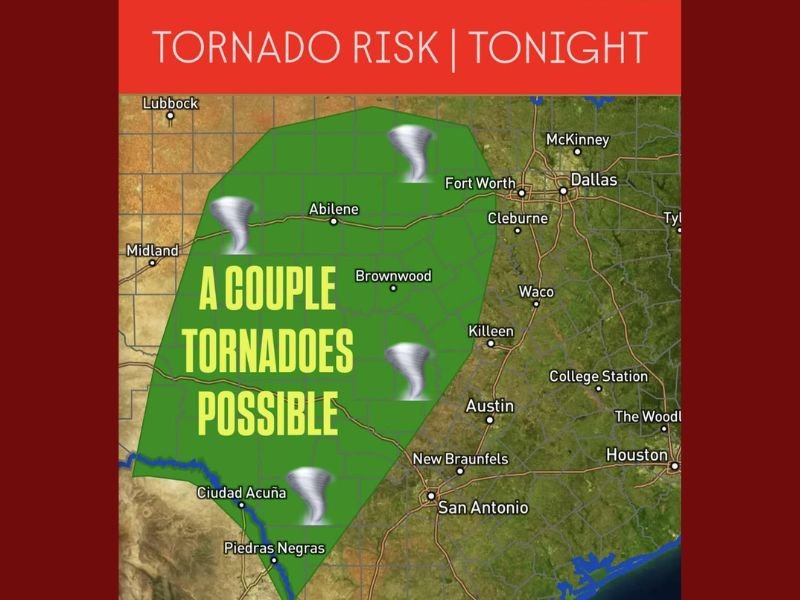
Meteorologists say a low-end tornado risk will remain in effect between 6 p.m. and 4 a.m., while the overall setup also favors heavy rainfall, hail, and strong wind gusts.
Storm Setup and Risk Zones
The latest forecast map shows an area of concern extending from west of Dallas-Fort Worth down through San Angelo, Austin, and New Braunfels, where “a couple of tornadoes are possible.”
This system is being driven by a surge of warm, moist air from the Gulf combining with a powerful cold front sweeping across the region. The result could be rotating thunderstorms capable of producing brief tornadoes and localized flash flooding.
“Even though the tornado threat is considered low, the environment will support a few storms that could spin up quickly,” forecasters warned. “Residents should not let their guard down tonight.”
Timing and Hazards
The greatest potential for severe weather will occur late this evening through early Wednesday morning, peaking between 9 p.m. and 2 a.m..
Key hazards include:
- Isolated tornadoes mainly across Central Texas
- Hail up to 1 inch in diameter
- Wind gusts exceeding 60 mph
- Localized flooding, particularly in low-lying or poorly drained areas
Cities such as Abilene, Waco, Austin, and Fort Worth are within the elevated zone for these overnight storms.
Safety Precautions for Residents
Officials are urging Texans to stay alert and have multiple ways to receive weather warnings overnight. Tornadoes that develop after dark are particularly dangerous due to reduced visibility.
Residents are advised to:
- Keep phones charged and volume on for emergency alerts
- Move vehicles to sheltered areas to avoid hail damage
- Avoid driving through flooded roads
Conditions will begin to improve by mid-morning Wednesday, with the front moving eastward toward Louisiana and Arkansas.
Stay with NapervilleLocal.com for real-time updates on this developing weather situation and for safety alerts as storms move through the state.

I’ve lived in Naperville long enough to see how quickly our community changes — from new developments downtown to sudden shifts in our Midwest weather. Reporting on Naperville news and daily forecasts gives me the chance to keep neighbors informed about what really matters. My goal is simple: deliver clear, timely updates so you always know what’s happening in our city and what to expect from the skies above.