
Tornado Watch Issued Across Georgia and South Carolina Until 1 PM as Storm Line Threatens Damaging Winds and Possible Tornadoes
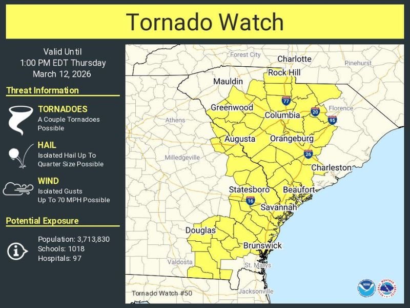
COLUMBIA, SOUTH CAROLINA — The U.S. National Weather Service has issued a Tornado Watch for parts of Georgia and South Carolina until 1:00 PM EDT Thursday, March 12, as a line of showers and thunderstorms sweeps across the Southeast bringing the potential for damaging winds and isolated tornadoes.
Forecasters say atmospheric conditions are favorable for severe thunderstorms capable of producing tornadoes, prompting officials to place large portions of the region under the watch as the storm system advances through the morning hours.
Line of Storms Moving Through the Southeast
Meteorologists are closely monitoring a fast-moving line of showers and thunderstorms pushing through Georgia and South Carolina, which could produce severe weather as it progresses eastward.
Communities including Augusta, Columbia, Greenwood, and Orangeburg fall within the watch zone where storms may briefly intensify. Cities along the coast and farther south such as Savannah, Beaufort, and Brunswick are also included in the watch area as the system moves across the region.
Tornadoes and Damaging Winds Possible
According to the National Weather Service, the tornado watch means a couple of tornadoes are possible as storms move through the region.
In addition to tornado potential, the strongest storms may produce:
- Damaging wind gusts up to 70 mph
- Isolated hail up to quarter size
- Heavy rain and lightning
While not every community will experience severe weather, meteorologists warn that brief tornado spin-ups could occur within the storm line, particularly during the morning hours.
Millions of Residents Within the Watch Area
The tornado watch covers a large portion of the Southeast, including major population centers across South Carolina and eastern Georgia. Officials estimate that more than 3.7 million people fall within the watch zone, including communities with over 1,000 schools and nearly 100 hospitals. Cities such as Rock Hill, Columbia, Augusta, Savannah, and Brunswick remain under the watch through early afternoon.
Residents Urged to Stay Weather-Aware
Emergency officials are encouraging residents across the region to remain weather aware and monitor updates from the National Weather Service as storms move through.
People in the watch area should ensure they have multiple ways to receive weather alerts, especially in case a Tornado Warning is issued. Residents are also advised to review tornado safety procedures and be ready to take shelter quickly if dangerous storms develop as the line continues moving across Georgia and South Carolina through the morning.

I’ve lived in Naperville long enough to see how quickly our community changes — from new developments downtown to sudden shifts in our Midwest weather. Reporting on Naperville news and daily forecasts gives me the chance to keep neighbors informed about what really matters. My goal is simple: deliver clear, timely updates so you always know what’s happening in our city and what to expect from the skies above.