
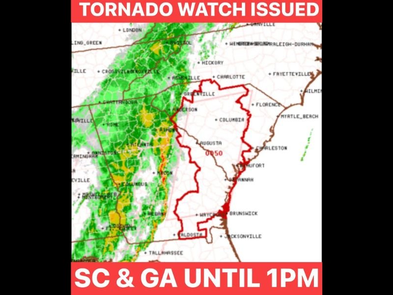
Tornado Watch Issued for South Carolina and Parts of Georgia Until 1 PM as Strong Storm Line Pushes Across the Southeast
GREENVILLE, SOUTH CAROLINA — A Tornado Watch has been issued for much of South Carolina and parts of Georgia until 1 PM, as a strong line of thunderstorms moves across the Southeast bringing heavy rain, gusty winds, and the potential for isolated tornadoes.
Forecasters say the watch was issued because conditions are favorable for tornado development, particularly as a band of storms continues pushing east through the region early today.
Strong Line of Storms Moving Across Georgia Toward South Carolina
Weather radar shows a large line of storms stretching across Georgia and moving toward the South Carolina Upstate, bringing widespread rain and occasional thunder.
Cities including Atlanta, Rome, and LaGrange in Georgia were already experiencing heavy rain and thunderstorms as the system advanced toward Greenville, Anderson, and surrounding communities in South Carolina.
Meteorologists say this advancing line of storms is currently the main weather concern, capable of producing brief spin-up tornadoes within the stronger cells.
Tornado Watch Covers Large Portion of South Carolina
The watch area includes much of South Carolina, particularly the southern Upstate, Midlands, and coastal areas, along with portions of eastern Georgia.
Communities such as Greenville, Columbia, Augusta, Savannah, and Brunswick fall within the watch zone where storms could briefly intensify.
While widespread tornado activity is not guaranteed, the atmosphere remains unstable enough for isolated tornadoes to develop within the storm line.
Heavy Rain and Thunder Expected as Storms Move Through
Along with the tornado risk, the storms are expected to bring periods of heavy rainfall, lightning, and gusty winds as they push through the region.
Forecasters say the most active weather will occur while the main storm line moves through, which may cause short bursts of intense rainfall and thunder across parts of the Carolinas and Georgia.
Threat Expected to Decrease After Initial Storm Line Passes
Meteorologists indicate that once the main line of storms moves through the region, the tornado threat should drop considerably. However, weather officials say they will continue monitoring conditions closely over the next several hours in case any additional storms develop behind the line.
Residents across South Carolina and Georgia are urged to stay alert for weather updates and be prepared to take shelter quickly if a Tornado Warning is issued.

I’ve lived in Naperville long enough to see how quickly our community changes — from new developments downtown to sudden shifts in our Midwest weather. Reporting on Naperville news and daily forecasts gives me the chance to keep neighbors informed about what really matters. My goal is simple: deliver clear, timely updates so you always know what’s happening in our city and what to expect from the skies above.