
Two Clipper Systems Expected to Bring Light Snow Accumulations and Colder Temperatures Across Central and Northern Indiana to End 2025 and Begin 2026
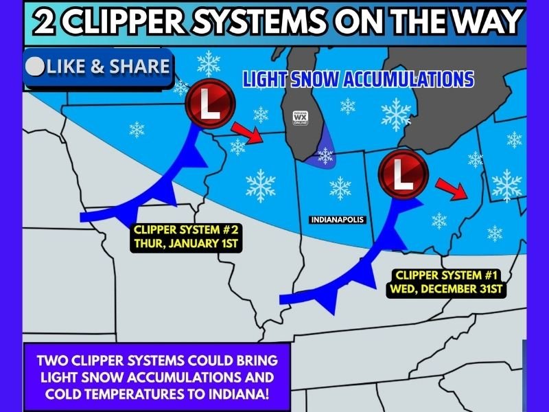
INDIANA — Two fast-moving Alberta clipper systems are expected to sweep across central and northern Indiana between December 31 and January 1, bringing bursts of light snow and a drop in temperatures as the region transitions into 2026. While neither system is expected to produce major snowfall, forecasters say minor accumulations are possible, especially across the northern half of the state.
Clipper systems are known for their quick pace, limited moisture, and brief windows of snowfall. Even so, these systems can still create slick conditions on untreated roads, particularly during early-morning and late-evening travel periods. Meteorologists caution residents to monitor updates as the systems approach.
First Clipper System Arrives Wednesday, December 31
The first clipper system is projected to move across Indiana on Wednesday, December 31. Forecast maps show the disturbance sliding southeastward across the Great Lakes and into the Midwest, bringing a light burst of snow to parts of northern and central Indiana.
Accumulation amounts are expected to remain minimal, but even a dusting to one inch could create locally slick spots, especially near Indianapolis, Fort Wayne, and surrounding communities. With colder air in place behind the system, any snow that falls may linger on untreated surfaces into the early hours of New Year’s morning.
Motorists traveling for holiday activities should be prepared for brief reductions in visibility and lightly coated roadways.
Second Clipper System to Follow on Thursday, January 1
A second clipper system is forecast to arrive on Thursday, January 1, reinforcing colder temperatures and delivering another round of light snow potential. This system follows a similar track to the first, with moisture moving in quickly and exiting just as fast.
Northern Indiana, particularly regions closer to the Michigan border, may see the highest chance for minor snow accumulation. Central Indiana, including Indianapolis, may see scattered flakes or light snow showers, though widespread accumulation remains limited.
Temperatures behind this second system will drop further, resulting in a colder start to the first weekend of 2026.
Light Snow, Breezy Conditions, and Cold Temperatures Expected
Both clippers will introduce breezy conditions that may enhance wind chills and create a sharper cold feel than recent days. High temperatures in the first week of January are expected to remain below normal across much of Indiana.
The combination of light snow, breezy winds, and falling temperatures may create spotty travel impacts. Pedestrians and drivers are advised to use caution on sidewalks, parking lots, bridges, and overpasses, where ice can form more quickly.
Forecasters emphasize that while these systems are not major winter storms, their timing — arriving during holiday travel — makes awareness especially important.
Looking Ahead: More Active Early January Pattern Possible
After the two clippers move through, Indiana may see additional disturbances during the early part of January depending on how the larger atmospheric pattern evolves. Long-range models indicate the potential for more active weather and occasional temperature swings heading into the second week of the month.
As always with clipper systems, timing and moisture availability can shift slightly as the disturbances approach. NapervilleLocal.com will continue to monitor updated snowfall projections, temperature trends, and regional advisories throughout the week.

I’ve lived in Naperville long enough to see how quickly our community changes — from new developments downtown to sudden shifts in our Midwest weather. Reporting on Naperville news and daily forecasts gives me the chance to keep neighbors informed about what really matters. My goal is simple: deliver clear, timely updates so you always know what’s happening in our city and what to expect from the skies above.