
Two Snow Systems Set to Sweep Across Illinois, Indiana, Michigan and Ohio Before Major March Warmup — Up to 6 Inches Possible Sunday Into Monday
UNITED STATES — A pair of late-winter snowmakers are lining up across the Midwest and Great Lakes just before the calendar flips to March, bringing two separate chances for accumulating snow this weekend into early next week.
Travelers with plans Saturday, Sunday, or Monday should pay close attention as both systems could create slick roads and measurable accumulation across parts of Illinois, Indiana, Michigan, and Ohio.
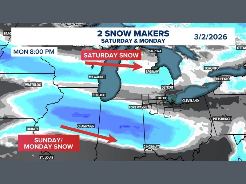
Round One: Saturday Snow From Minnesota to Michigan
The first system arrives Saturday, tracking west to east from Minnesota through central and southern Michigan.
Snow will push across areas near:
- Milwaukee
- Chicago
- Detroit
- Saginaw
- Surrounding portions of central and southern Michigan
This initial round is expected to bring several inches in localized areas, particularly across southern Michigan. While snowfall totals may vary, enough accumulation is likely to create travel slowdowns Saturday afternoon into Saturday night.
Round Two: Stronger System Sunday Into Monday
The second round appears more impactful.
This system develops Sunday and strengthens into Monday, with a broader swath of snow extending from Illinois and Indiana into Ohio.
Cities that could see accumulating snow include:
- Chicago
- Champaign
- Fort Wayne
- Toledo
- Cincinnati
- Cleveland
- Parts of central and southern Indiana and Ohio
Forecast guidance suggests up to 6 inches of snow may fall in parts of Illinois, Indiana, and Ohio, particularly from Sunday into Monday morning.
The heaviest band currently appears oriented from central Illinois eastward through Indiana and into southwestern Ohio.
Travel Concerns This Weekend
With snow expected on both Saturday and again Sunday into Monday, road conditions could deteriorate quickly, especially during peak travel windows.
Drivers should prepare for:
- Reduced visibility during heavier snow bands
- Slushy and snow-covered highways
- Potential delays at major Midwest hubs
Those traveling between Chicago, Detroit, Cincinnati, Cleveland, and surrounding corridors should monitor updated forecasts closely.
Big March Warmup Still Ahead
Despite these two winter systems, forecasters emphasize that a much larger pattern shift toward warmer conditions remains on track for early March.
In fact, once these snow chances pass, attention turns toward a significant warmup — potentially even record-challenging warmth in parts of the country.
But first, the Midwest must get through these final winter shots.
What to Expect
- Saturday: Snow tracking from Minnesota into Michigan
- Sunday into Monday: Stronger system from Illinois and Indiana into Ohio
- Up to 6 inches possible in parts of IL, IN, and OH
- Travel impacts likely across the Midwest and Great Lakes
- Major warmup follows next week
Winter isn’t quite finished yet — but its grip may be loosening soon.
For continued Midwest and national weather updates, stay with NapervilleLocal.com.

I’ve lived in Naperville long enough to see how quickly our community changes — from new developments downtown to sudden shifts in our Midwest weather. Reporting on Naperville news and daily forecasts gives me the chance to keep neighbors informed about what really matters. My goal is simple: deliver clear, timely updates so you always know what’s happening in our city and what to expect from the skies above.