
U.S. Could Swing From Mid-February Thaw to Late-Winter Storm “Battle Zone” as Extreme Cold Pools in Western Canada, Model Map Warns
UNITED STATES — A new temperature anomaly map tied to the EURO/ECMWF model is highlighting a dramatic mid-to-late February setup: a broad mid-February thaw across much of the United States, while extreme cold remains parked in western Canada, creating the ingredients for a stronger storm corridor and a possible return to winter weather late in February and into early March.
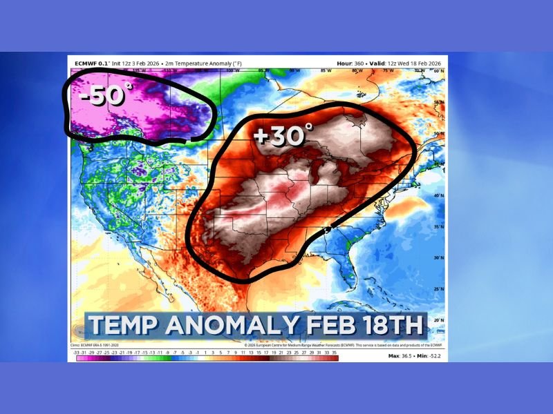
The graphic is labeled as a 2-meter temperature anomaly forecast valid Wednesday, February 18, 2026, and the commentary attached to it describes a pattern that may not stay calm for long. The key concern isn’t only the warmth—it’s what happens when warmth expands while a deep reservoir of cold sits nearby, waiting to be pulled south.
What the Feb. 18 anomaly map is showing
The map shows a large area of the central and eastern United States shaded in warmer colors, with a bold callout near the middle of the country indicating “+30°”—a signal of temperatures running far above average for the date. That warm anomaly covers a wide footprint, stretching across much of the Plains, Midwest, and toward the Great Lakes and interior East.
At the same time, the upper-left portion of the map over western Canada is highlighted with an extreme cold callout of “-50°”, signaling a significant cold pool lingering just north of the U.S. border region.
Why the Canada cold pool matters
The commentary in the data notes that the cold isn’t gone—it’s simply displaced and waiting. When a major warm surge pushes north and a cold reservoir remains bottled up in Canada, it often sets the stage for a stronger temperature gradient across North America. That sharp contrast can become the fuel for larger storm systems, especially when the jet stream positions itself along the boundary.
This is what the post refers to as a developing “battle zone”—an area where competing air masses clash, often creating more frequent or more intense storm tracks.
Mid-to-late February could turn more active
According to the text provided, the expected result is a mid-to-late February battle zone with bigger storm systems, and it even notes that some severe weather may be possible depending on how the atmosphere organizes along that boundary.
The post also warns that after the thaw, there could be a return to winter weather later in February and as March begins—suggesting the warm period may be a temporary surge rather than a season-ending shift.
What to watch as February moves into its second half
If the warmth dominates early, impacts could include melting snowpack and faster thawing across colder regions. But if the cold pool drops south and the storm track becomes more active, the second half of February could pivot quickly into a more volatile pattern—one that supports heavier precipitation events and sharper temperature swings.
The core takeaway from the provided data is that February’s second half and early March could get “interesting” fast, with a thaw, a nearby Arctic reservoir, and a potential storm corridor all lining up at the same time.
Are you noticing big temperature swings where you live right now—warm one week, winter the next? Share what you’re seeing and keep following NapervilleLocal.com for ongoing pattern updates as the late-winter setup evolves.

I’ve lived in Naperville long enough to see how quickly our community changes — from new developments downtown to sudden shifts in our Midwest weather. Reporting on Naperville news and daily forecasts gives me the chance to keep neighbors informed about what really matters. My goal is simple: deliver clear, timely updates so you always know what’s happening in our city and what to expect from the skies above.