
U.S. Weather Outlook Flips Again: Warmer Temperatures Likely Into Mid-February Before Colder Pattern Returns Late Month
UNITED STATES — New federal weather outlooks show a temporary shift toward warmer-than-average temperatures across much of the country through mid-February, before signs point to a return of colder air later in the month. The updated guidance reflects a recent reversal by the Climate Prediction Center, which now favors above-average temperatures and increased precipitation in the short term.
The outlooks, issued February 2, 2026, include 6–10 day, 8–14 day, and monthly February temperature projections, all of which suggest an active and changing pattern rather than a stable winter setup.
Warmer temperatures favored through mid-month
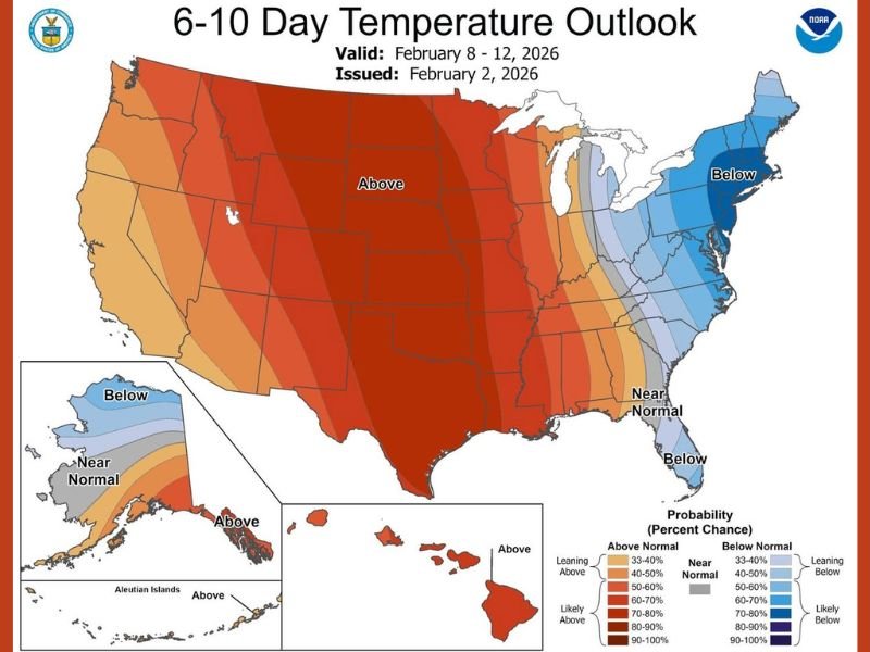
The 6–10 day temperature outlook (valid February 8–12) shows above-normal temperatures dominating much of the central and western United States, extending into parts of the South and Plains. This marks a clear shift from earlier expectations of sustained cold, indicating that milder air is temporarily winning out.
That trend continues in the 8–14 day temperature outlook (February 10–16), which expands the area of likely above-average temperatures across a large portion of the country. These projections suggest that many regions could experience a break from harsh winter cold as February moves toward the middle of the month.
Precipitation outlook shows wetter conditions
Alongside the temperature reversal, the 8–14 day precipitation outlook now favors above-average rainfall across a wide stretch of the United States. This suggests a more active storm track, with increased chances for rain, mixed precipitation, or snow depending on local temperatures.
The combination of milder air and higher precipitation odds raises the potential for unsettled weather, including heavy rain events in warmer regions and slushy or mixed winter weather where temperatures hover near freezing.
Colder air still possible later in February
Despite the mid-month warm signal, longer-range indicators show winter may not be finished. Meteorologists referenced in the discussion note that model guidance still points to a potential polar vortex disruption around mid-month, which could allow colder air to spill southward during the latter part of February.
This is reflected in the monthly February temperature outlook, which shows portions of the country trending colder than normal overall, even if the first half of the month skews warmer. The message is clear: the warmer stretch may be temporary.
What this pattern means overall
Taken together, the outlooks point to a volatile February, with warmth, increased precipitation, and shifting air masses all in play. Short-term relief from cold is likely, but the atmosphere appears poised to reload with colder conditions before winter fully loosens its grip.
For now, forecasters caution against assuming winter is over just because temperatures rise briefly.
Have you noticed the back-and-forth pattern this winter where warm spells quickly give way to cold again? Share what you’re experiencing and follow ongoing national weather coverage at NapervilleLocal.com.

I’ve lived in Naperville long enough to see how quickly our community changes — from new developments downtown to sudden shifts in our Midwest weather. Reporting on Naperville news and daily forecasts gives me the chance to keep neighbors informed about what really matters. My goal is simple: deliver clear, timely updates so you always know what’s happening in our city and what to expect from the skies above.