
United States Sees Rare Nationwide Break from Severe Storms as No Thunderstorms Expected Across Multiple States for Next 8 Days
UNITED STATES — After a week marked by repeated severe weather outbreaks, a dramatic nationwide pattern shift is bringing an unusual stretch of calm conditions, with forecasters indicating little to no thunderstorm activity across the country for the next eight days.
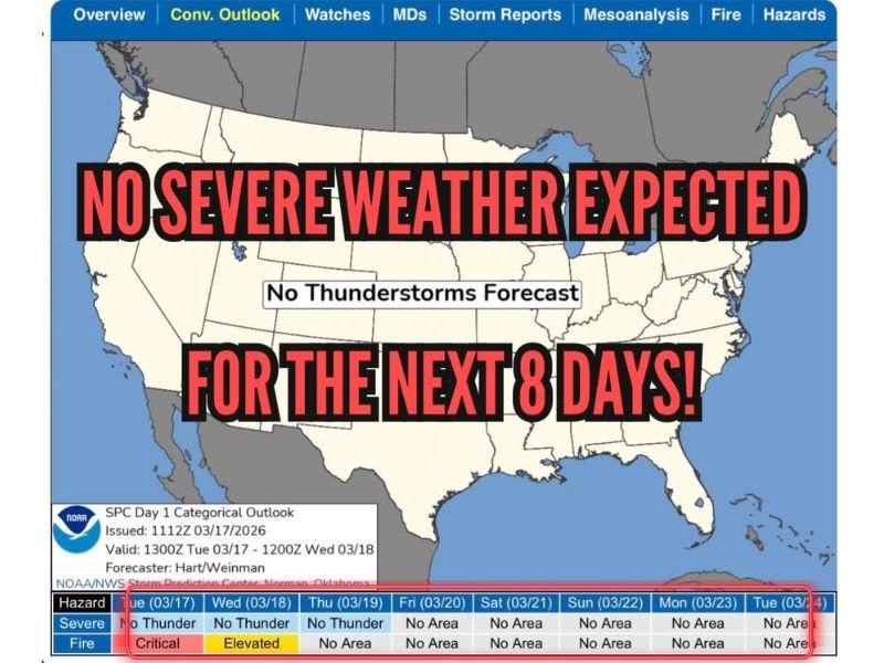
Forecast data from the Storm Prediction Center shows a complete absence of severe weather zones, signaling a rare quiet period across nearly all states. This break comes as a welcome relief following days of active storm systems that impacted multiple regions.
Nationwide Calm Replaces Active Storm Pattern
The latest outlook map highlights a striking change: no organized thunderstorm risk areas across the continental United States through at least the next week.
States across the Midwest, South, Great Plains, Southeast, and Northeast — including Illinois, Texas, Oklahoma, Arkansas, Mississippi, Alabama, Tennessee, and beyond — are expected to remain free from severe storm threats during this period.
This type of widespread calm is uncommon during early spring, a time typically known for increasing severe weather activity.
Fire Weather Concerns Replace Storm Threats
While severe thunderstorms are not expected, the forecast does indicate elevated to critical fire weather conditions, particularly in parts of the central and southern Plains.
Dry air, gusty winds, and low humidity levels are creating an environment favorable for wildfire spread in some regions. This means that while storms are absent, other weather-related risks remain.
What’s Driving This Quiet Pattern?
Meteorologists point to a more stable atmospheric setup, where the usual ingredients for severe storms — including strong instability, moisture, and wind shear — are not aligning.
Instead, a more zonal and less dynamic pattern is dominating, preventing the development of organized storm systems. Without strong disturbances moving across the country, thunderstorm formation remains limited.
A Temporary Break Before Peak Season
This calm stretch is expected to be temporary. As the calendar moves deeper into spring, conditions typically become more favorable again for severe weather across the Plains and Midwest.
For now, however, the absence of storm threats provides an opportunity for recovery in areas recently impacted by damaging weather.
Final Outlook
The next 8 days are shaping up to be one of the quietest periods in recent weeks across the United States, with no severe thunderstorms expected nationwide.
Residents across all regions can expect a break from hazardous weather, though those in fire-prone areas should remain cautious. Meteorologists will continue monitoring for any changes, but for now, the message is clear: a rare and much-needed pause in severe weather has arrived.

I’ve lived in Naperville long enough to see how quickly our community changes — from new developments downtown to sudden shifts in our Midwest weather. Reporting on Naperville news and daily forecasts gives me the chance to keep neighbors informed about what really matters. My goal is simple: deliver clear, timely updates so you always know what’s happening in our city and what to expect from the skies above.