
United States Weekend Snow Rumors for the South and East Debunked as Forecasts Show No Winter Storm Development
United States — Meteorologists are pushing back against growing online speculation about a potential weekend snow event across the southern and eastern United States, confirming that no snow, flurries, or winter storm impacts are expected in the region. Despite social media posts highlighting long-range EURO and GFS model snowfall maps, forecasters stress that the official forecast shows no winter weather threat developing. The circulating graphics are being widely misinterpreted, leading to unnecessary concern across parts of the Southeast and East Coast.
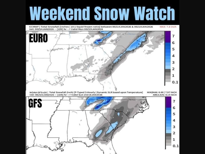
Why the EURO and GFS Snow Maps Are Misleading
The images being shared are based on long-range model output, which often displays light snowfall shading far beyond reliable forecast windows. At these extended time frames, the models are showing theoretical precipitation signals, not confirmed weather events.
Meteorologists emphasize that these maps do not account for realistic surface temperatures, moisture availability, or storm organization, all of which are currently absent. As a result, the shaded snow areas do not translate into real-world snowfall.
No Snow or Flurries Included in the Official Forecast
Forecast messaging accompanying the data clearly states that:
- No flurries are expected
- No snow is in the forecast
- No winter storm system is developing
Short-range guidance, which is significantly more reliable than long-range projections, shows no atmospheric setup capable of producing snow across the South or East this weekend.
Areas Being Discussed Are Outside the Midwest
The geographic focus of the model imagery is limited to the southern and eastern United States, including parts of the Southeast and Mid-Atlantic. Illinois, the Midwest, Chicago, and Naperville are not included or referenced anywhere in the data. This distinction is critical, as the content is meant to dispel misinformation, not announce a weather threat.
Why This Clarification Matters
Misinterpreted weather graphics can lead to:
- Unnecessary travel cancellations
- Public confusion
- Loss of trust in local weather reporting
Forecasters caution that model screenshots without context are one of the most common sources of winter weather misinformation, especially during active seasonal transitions.
What Residents Should Expect Instead
At this time, residents across the South and East should expect normal seasonal conditions, not snow or winter storm impacts. Forecast confidence remains high that no weekend snow event will occur.
Weather experts advise the public to rely on official forecasts and short-range guidance, rather than speculative long-range imagery shared online.
NapervilleLocal.com will continue providing verified, location-accurate weather reporting and clear explanations when national forecast discussions may affect broader public understanding.

I’ve lived in Naperville long enough to see how quickly our community changes — from new developments downtown to sudden shifts in our Midwest weather. Reporting on Naperville news and daily forecasts gives me the chance to keep neighbors informed about what really matters. My goal is simple: deliver clear, timely updates so you always know what’s happening in our city and what to expect from the skies above.