
United States Winter Pattern Shifts as Disrupted Polar Vortex Signals Unusual Arctic Cold in Late January
United States — New atmospheric data and long-range model analysis indicate a significant shift in the winter weather pattern developing across the United States, driven by a disruption of the polar vortex that could allow Arctic air to move much farther south than usual during the second half of January.
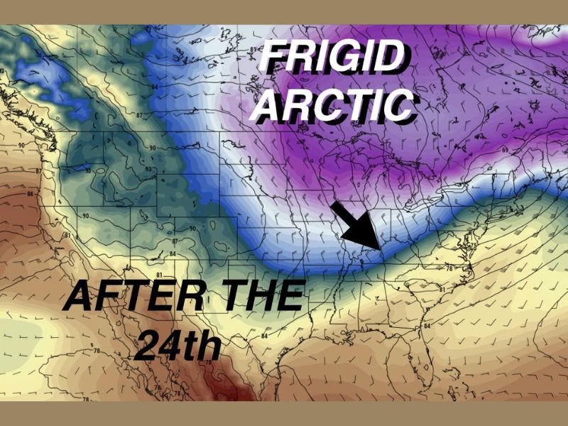
Meteorologists reviewing upper-level conditions report that this change is already beginning, with the core of the polar vortex expected to settle over eastern Canada. When this occurs, it can open a pathway for cold Arctic air to spill southward into the central and eastern portions of the country, marking a notable and potentially long-lasting cold pattern.
Why This Polar Vortex Event Is Unusual
Polar vortex disruptions of this magnitude are not common. In many winters, a major disruption occurs once every couple of years, making a second significant event in the same season highly unusual.
This disruption is linked to a Sudden Stratospheric Warming, a process in which temperatures high in the atmosphere rise rapidly, weakening the polar vortex and causing it to become unstable. As a result, the jet stream becomes more wavy, allowing cold air to push south while warmer air moves north in other regions. Unlike minor disruptions that lead to brief cold snaps, current guidance suggests this event may be strong enough to persist, increasing the likelihood that its effects could linger into late January.
Expected Temperature Trends Across the U.S.
As Arctic air is drawn southward, much of the northern United States could experience prolonged periods of very cold temperatures. Forecast discussion associated with this pattern suggests:
- Limited chances for sustained warming
- Repeated intrusions of Arctic air
- Daytime highs remaining well below seasonal averages
- Overnight lows potentially dropping into the teens or single digits in colder regions
In some northern areas, temperatures may struggle to rise above freezing for extended stretches, especially if reinforcing cold air masses continue to move south.
Increased Risk for Winter Storm Development
This evolving pattern may also favor winter storm development, particularly as cold air interacts with moisture moving north from the Gulf Coast. These setups can support winter precipitation events between the Gulf Coast and the East Coast, depending on storm track and timing.
One potential concern highlighted by forecasters is the increased risk of freezing rain and ice, especially in situations where cold air becomes trapped near the surface while warmer air moves overhead. Ice events often cause greater disruption than snow, leading to hazardous travel, power outages, and infrastructure stress.
However, meteorologists emphasize that precipitation type and storm specifics cannot be determined yet, with confidence increasing only three to four days ahead of individual systems.
How Long the Pattern Could Persist
Current indications suggest this colder pattern may extend through the latter half of January, rather than ending after a short cold outbreak. The wavy jet stream configuration associated with the disrupted polar vortex can allow Arctic air to reload repeatedly, keeping temperatures suppressed even between storm systems.
While exact impacts will vary by region, the broader signal points to a colder-than-normal and more active winter pattern across large portions of the United States. For continued coverage of emerging weather patterns, seasonal outlooks, and verified updates, follow NapervilleLocal.com, where we focus on accuracy, clarity, and responsible reporting as new data becomes available.

I’ve lived in Naperville long enough to see how quickly our community changes — from new developments downtown to sudden shifts in our Midwest weather. Reporting on Naperville news and daily forecasts gives me the chance to keep neighbors informed about what really matters. My goal is simple: deliver clear, timely updates so you always know what’s happening in our city and what to expect from the skies above.