
Unseasonably Warm Christmas Pattern Expected Across Texas, Oklahoma, Arkansas, Louisiana, Mississippi and the Southeast, NWS Says
TEXAS — A significant shift toward warmer-than-normal temperatures is expected across Texas, Oklahoma, Arkansas, Louisiana, Mississippi and much of the Southeast heading into the week of December 19–25, according to the latest National Weather Service (NWS) guidance. Forecast models suggest a broad warm spell may dominate large portions of the Central and Southern United States just days before Christmas.
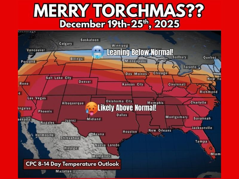
NWS Outlook Shows “Likely Above Normal” Temperatures
The National Weather Service has updated its 8–14 Day Temperature Outlook to indicate that much of the South and Central U.S. will trend warmer than normal from December 19 through December 25. States including Texas, Louisiana, Mississippi, Arkansas and Oklahoma are positioned firmly within the “Likely Above Normal” temperature zone.
This pattern, often referred to colloquially as “torch” conditions, marks a notable departure from typical mid-December cold. Instead, widespread highs will run significantly warmer than seasonal averages, potentially altering holiday expectations for millions across the region.
Warm Weather Signals Possible Storm Development After Christmas
Meteorologists caution that while warm December weather may seem pleasant, it often signals atmospheric instability that can lead to more impactful weather afterward. When the Central and Southern U.S. experience a December warm wave, a strong storm system frequently follows, bringing the potential for heavy rain, high winds or even severe thunderstorms.
Early ensemble guidance suggests December 26th through 29th may require close monitoring, as shifting temperatures could intensify conditions once the warm spell begins to break down. Although there is still uncertainty, forecasters emphasize that the setup fits patterns commonly associated with post-warm-up storm activity.
Below-Normal Temperatures Remain Possible in the Northern Tier
While the South trends much warmer, the latest ensemble maps show a contrasting region of leaning-below-normal temperatures across the northern Plains and upper Midwest, including areas near Minnesota and the Dakotas. This boundary between cold northern air and unusually warm southern air may serve as the driver for potential late-month storm development.
Holiday Travel Could Be Affected by Weather Shifts
With Christmas approaching, millions of Americans will be on the move, making the evolving temperature pattern especially important for travelers. The warm spell may create easier driving conditions in the short term across Southern states, but any strong system developing between December 26 and 29 could disrupt post-holiday travel.
Forecast confidence will increase as models continue to update, and meteorologists recommend checking for new guidance multiple times per week as Christmas approaches.
Outlook
For now, the message is clear: the Central and Southern U.S. are likely heading into a much warmer-than-normal stretch leading up to Christmas, with potential weather impacts following shortly after.
Stay with NapervilleLocal.com for ongoing weather updates throughout December.

I’ve lived in Naperville long enough to see how quickly our community changes — from new developments downtown to sudden shifts in our Midwest weather. Reporting on Naperville news and daily forecasts gives me the chance to keep neighbors informed about what really matters. My goal is simple: deliver clear, timely updates so you always know what’s happening in our city and what to expect from the skies above.