
Warm, Sticky, and Breezy Monday Grips Little Rock, Fort Smith, and Helena With Upper 70s to Mid-80s as Severe Storm Threat Builds for Western Arkansas Tuesday and Wednesday
LITTLE ROCK, Ark. — Summer is making its presence felt across Arkansas today, and residents are going to feel every bit of it. A warm, humid, and breezy Monday is settling across the state with high temperatures climbing into the upper 70s and low 80s statewide — and dewpoints surging into the 60s and low 70s adding a thick, sticky quality to the air that signals the warm season has truly arrived.
The heat today is just the opening act, with a more serious severe weather threat building for western Arkansas as soon as tomorrow evening.
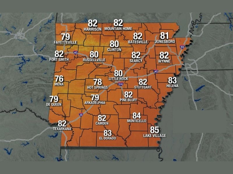
Upper 70s to Mid-80s Blanket the Entire State
Temperatures today are running uniformly warm from the Missouri border all the way to the Louisiana state line. Lake Village leads the state at a steamy 85°F, followed by Monticello at 84°F and El Dorado at 83°F across the southern tier.
Central and eastern Arkansas communities are sitting in the low 80s, with Searcy, Pine Bluff, Stuttgart, and Wynne all reaching 82°F. Little Rock tops out at 80°F, while Harrison and Mountain Home hit 82°F in the north. Western Arkansas runs slightly cooler, with Fayetteville at 79°F, Mena at 76°F, and De Queen at 79°F.
Dewpoints in the 60s and 70s Make It Feel Sticky
The raw temperature numbers only tell part of today’s uncomfortable story. Dewpoints climbing into the 60s and touching the low 70s across portions of the state are dramatically increasing the humidity factor, giving the air a thick and oppressive feel that will make outdoor activity noticeably more draining than the thermometer alone might suggest.
This is the kind of air that reminds Arkansans that summer is no longer a distant concept — it has arrived and settled in.
Gusts 20 to 30 MPH — Even Stronger Tonight at Elevation
Adding another layer to today’s unsettled feel, breezy conditions will be a persistent feature throughout the day with wind gusts reaching 20 to 30 mph at times across the state. Higher elevation areas could see gusts exceeding 30 mph tonight as winds remain active into the overnight hours.
Severe Storm Threat Eyes Western Arkansas Tuesday and Wednesday
While today stays mainly dry, forecasters are closely tracking storm chances developing for tomorrow evening and again on Wednesday — with western Arkansas carrying the greatest severe weather risk during that window. Some of those storms could reach severe levels, though full details on timing and impacts are still being refined.
Residents across western Arkansas communities including Fort Smith, Fayetteville, and surrounding areas should monitor updated forecasts closely through the day today and have their severe weather plans ready heading into Tuesday evening. Stay with NapervilleLocal.com for the latest weather updates and local forecast coverage.

I’ve lived in Naperville long enough to see how quickly our community changes — from new developments downtown to sudden shifts in our Midwest weather. Reporting on Naperville news and daily forecasts gives me the chance to keep neighbors informed about what really matters. My goal is simple: deliver clear, timely updates so you always know what’s happening in our city and what to expect from the skies above.