
Washington and Oregon Brace for Major Atmospheric River Bringing Up to 20 Inches of Rain and Heavy Mountain Snow
WASHINGTON — A powerful atmospheric river is set to drench the Pacific Northwest this week, bringing relentless heavy rain, flooding risks, and mountain snow accumulations reaching several feet. Meteorologists say the system, fueled by a steady stream of Pacific moisture, will begin intensifying on Wednesday, impacting much of Washington, Oregon, and parts of Idaho through the weekend.
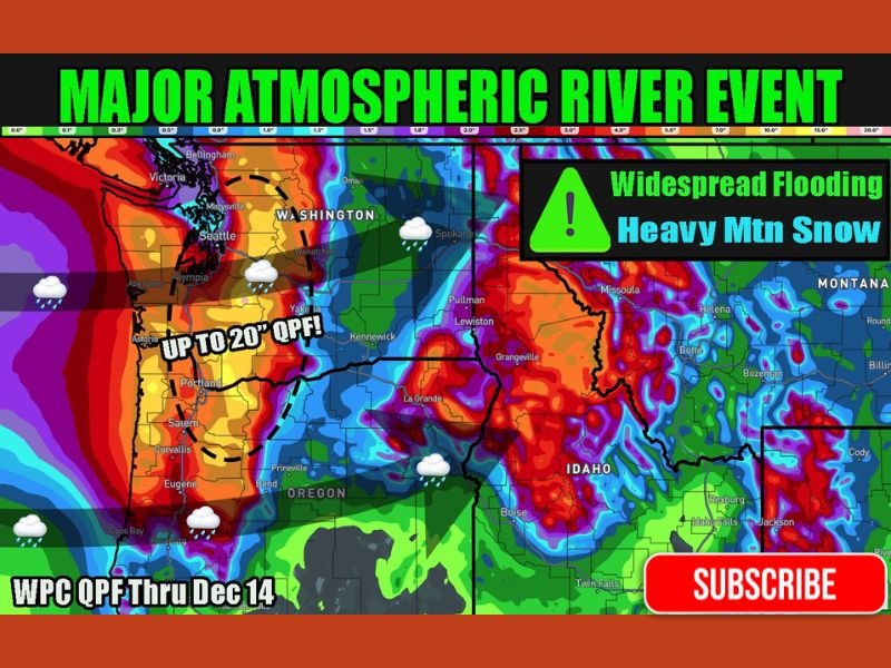
According to forecasts from the Weather Prediction Center (WPC), total precipitation amounts could exceed 15 to 20 inches in some areas, particularly along the coastal ranges and western slopes of the Cascades. The persistent moisture feed — known as an atmospheric river — will also produce strong winds, high surf, and potential landslides as soils become saturated from continuous rainfall.
Heavy Rain and Flooding Threat
Communities across western Washington and northwestern Oregon are being advised to prepare for flash flooding and river rises. The heaviest rainfall totals are expected in cities such as Seattle, Olympia, and Portland, where rainfall could exceed 5 to 7 inches through the end of the week.
Low-lying areas and regions near rivers, including the Willamette Valley and Puget Sound basin, face heightened flood potential. Emergency management officials warn that the combination of heavy rain and melting snow could lead to rapid runoff, making travel hazardous and flooding possible in urban corridors and rural zones alike.
Mountain Snow and Travel Impacts
While rain will dominate lower elevations, mountain regions across the Cascades and northern Idaho are forecast to receive multiple feet of snow, creating dangerous conditions for travelers and increasing avalanche concerns. Higher passes such as Snoqualmie Pass and Stevens Pass may experience periods of whiteout conditions and icy roads through Friday, prompting potential travel restrictions.
Forecasters say the combination of tropical Pacific moisture and cold air from the north will keep snow levels fluctuating — meaning some areas could see both heavy rain and snow within short distances. The National Weather Service emphasizes caution for anyone traveling across the mountains or near flood-prone waterways.
Long-Duration Storm Outlook
This event is expected to be one of the most significant atmospheric rivers to impact the Pacific Northwest this season, with several days of continuous precipitation likely. The system could bring additional rounds of rain and snow into early next week as the Pacific jet stream remains active.
Meteorologists are urging residents in Washington, Oregon, and Idaho to monitor updated forecasts, stay alert for flood warnings, and prepare for extended periods of hazardous weather. For continued coverage and local updates, visit NapervilleLocal.com for the latest regional weather developments.

I’ve lived in Naperville long enough to see how quickly our community changes — from new developments downtown to sudden shifts in our Midwest weather. Reporting on Naperville news and daily forecasts gives me the chance to keep neighbors informed about what really matters. My goal is simple: deliver clear, timely updates so you always know what’s happening in our city and what to expect from the skies above.