
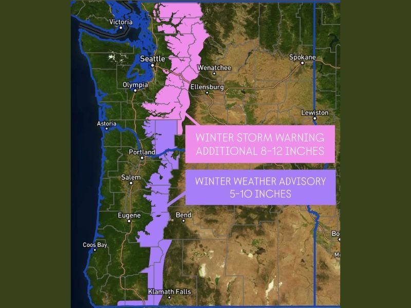
Washington and Oregon Cascades Face Major Travel Disruptions as Winter Storm Warning and Weather Advisory Forecast 8–12 Inches of New Snow
Washington and Oregon — A powerful winter system is bringing significant snowfall to the Cascades, prompting a Winter Storm Warning for the Washington Cascades and a Winter Weather Advisory for the Oregon Cascades. Weather officials warn that mountain passes will be affected as the storm delivers 8–12 additional inches of snow in Washington and 5–10 inches across Oregon from early Sunday through early Monday.
Heavy Snowfall Expected to Intensify Across the Cascades
Forecasters report that the Washington Cascades will see the greatest impact, with additional snowfall of 8–12 inches expected through midnight. The advisory zone in Oregon is forecast to receive 5–10 inches, a range still capable of producing hazardous travel and reducing visibility along major mountain corridors.
Meteorologists note that this system is part of a larger pattern sending repeated waves of Pacific moisture into the Northwest, creating conditions favorable for intense snow bands, slick roadways, and cold, gusty winds. As a result, both states are urging travelers to plan ahead, monitor changing conditions, and avoid mountain travel unless necessary.
Impact on Mountain Passes and Regional Travel
The winter storm is expected to significantly affect travel through the Washington and Oregon Cascades, particularly in well-traveled mountain passes. Officials warn that drivers may encounter snowpacked roads, rapidly accumulating snow, and periods of near-whiteout visibility. Chains, traction tires, and emergency supplies are strongly recommended for anyone who must travel during the storm window.
Communities near Wenatchee, Ellensburg, Bend, and Klamath Falls are likely to feel the effects of the storm, especially in higher elevations where snowfall rates can increase quickly. Road crews are preparing for continuous clearing operations as conditions are expected to fluctuate through Sunday night and early Monday morning.
Ongoing Weather Alerts and What Residents Should Expect
The National Weather Service advises that conditions could change rapidly, with the potential for advisory areas to be upgraded if snowfall intensifies. Forecasters highlight the possibility of isolated higher totals in ridge-top locations or areas where prolonged bands of snow set up.
Residents and travelers are encouraged to stay informed, especially as the storm may influence school schedules, business operations, and regional transportation. The combination of heavy snow, cold temperatures, and reduced visibility underscores the importance of preparing for delays and monitoring official weather alerts. For continued updates on winter weather impacts in the Pacific Northwest and national weather developments, visit NapervilleLocal.com for the latest reports.

I’ve lived in Naperville long enough to see how quickly our community changes — from new developments downtown to sudden shifts in our Midwest weather. Reporting on Naperville news and daily forecasts gives me the chance to keep neighbors informed about what really matters. My goal is simple: deliver clear, timely updates so you always know what’s happening in our city and what to expect from the skies above.