
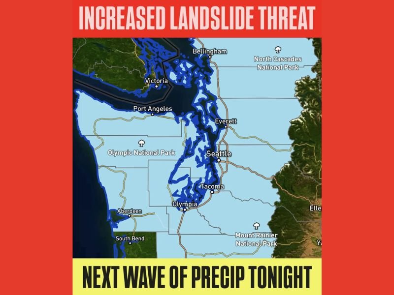
Washington and Oregon Face Serious Landslide Threat as New Moisture Wave Hits the Pacific Northwest Tonight
WASHINGTON & OREGON — Another strong wave of Pacific moisture is set to move into the Pacific Northwest tonight and continue through Thursday, bringing heavy rainfall, already-saturated soils, and a significantly elevated threat of landslides across large portions of Western Washington and western Oregon. Officials and forecasters are urging residents to remain alert as the region faces yet another dangerous round of weather impacts.
Heaviest Rainfall Expected From SW Washington Into Western Oregon
According to the latest projections, the heaviest rain will target southwestern Washington and western Oregon, where moisture is expected to funnel inland throughout the night. Many communities in these regions have already endured days of continuous rainfall, which has weakened soil structure and increased the potential for slope failures.
The rainfall tonight will contribute to an escalating situation, with forecasters noting that even moderate precipitation falling on top of unstable ground can trigger landslides, debris flows, and rapid slope movement. Areas near major foothills, river valleys, and steep terrain—including Port Angeles, Olympia, Tacoma, Everett, and Seattle—remain especially vulnerable.
Why the Risk Has Escalated: Saturated Soils and Continuous Storms
What makes this incoming moisture event particularly dangerous is the extreme level of soil saturation across much of Western Washington. Over the past week, the region has experienced multiple atmospheric disturbances, each delivering heavy rain. As a result, drainage systems, hillsides, and slopes are at or near full capacity.
This new wave of moisture will add pressure to an already fragile landscape. Forecasters warn that landslides often occur after prolonged rainfall rather than during isolated storm bursts, meaning the combination of recent storms and tonight’s incoming precipitation significantly raises the threat level.
In addition, localized flooding remains possible in low-lying areas, especially where storm drains are clogged or where persistent runoff channels have already formed.
Communities Urged to Stay Alert and Monitor Changing Conditions
Residents are encouraged to watch for key warning signs of potential landslides, such as rapid ground movement, leaning trees, sudden cracks in soil or pavement, unusual sounds such as rumbling or popping, and changes in water flow patterns. Those living on or below steep slopes should be prepared to relocate temporarily if conditions worsen.
Forecasters say the landslide threat will continue into Thursday, particularly in areas experiencing the highest rainfall intensity. Emergency officials stress the importance of staying updated through local alerts and maintaining situational awareness as conditions evolve.
As the Pacific Northwest braces for yet another challenging weather event, residents are reminded to take precautions, avoid unnecessary travel in high-risk areas, and stay informed through trusted updates. For ongoing coverage and community updates, visit NapervilleLocal.com.

I’ve lived in Naperville long enough to see how quickly our community changes — from new developments downtown to sudden shifts in our Midwest weather. Reporting on Naperville news and daily forecasts gives me the chance to keep neighbors informed about what really matters. My goal is simple: deliver clear, timely updates so you always know what’s happening in our city and what to expect from the skies above.