
Washington Faces Major Flooding Threat as More Than a Dozen Rivers Expected to Reach Major Flood Stage After New Atmospheric River Surge
WASHINGTON — A powerful second wave of atmospheric river moisture is expected to slam into Washington tonight and continue through Wednesday, setting the stage for widespread and potentially historic river flooding across the state. Forecasters warn that more than a dozen rivers are projected to reach major flood stage between Wednesday night and Thursday, with several waterways at risk of reaching all-time record levels.
This incoming surge follows an earlier round of heavy rain, but meteorologists say the next punch will be significantly more impactful due to saturated ground, full river basins, and a prolonged period of high-intensity rainfall.
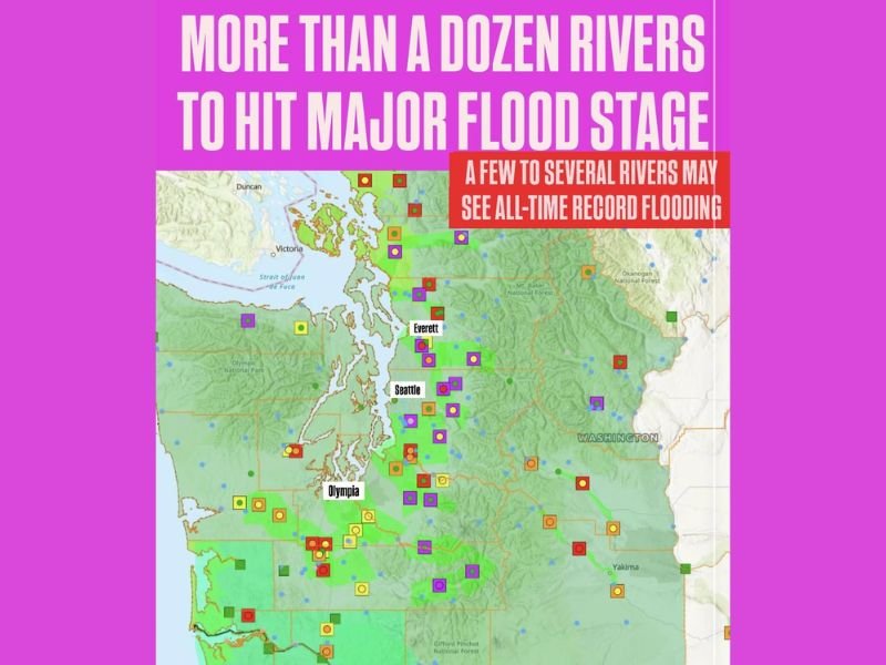
Dozens of Rivers at Risk Across Western and Central Washington
The updated flood mapping, highlighted with purple and pink indicators, shows a dense cluster of at-risk rivers stretching from:
- The Olympic Peninsula
- Puget Sound region including Seattle, Everett, and Olympia
- Cascade foothills and valley communities
- Parts of Central Washington including Yakima
Many of these rivers are already running high, and with another atmospheric river arriving, hydrologists warn conditions could deteriorate quickly.
Several Rivers Could Reach All-Time Record Flooding
Alongside widespread major flooding, a smaller—but critical—subset of rivers could set new historic flood records, surpassing events from previous decades. This includes sensitive watersheds known for rapid rises during heavy rainfall.
Residents living near flood-prone rivers, creeks, and low-lying areas are urged to stay vigilant and monitor alerts.
Why This Round Is More Dangerous
Meteorologists explain that the upcoming system is stronger and carries more moisture, creating a higher-impact scenario:
- Soils are already saturated, leaving little room for additional absorption.
- Runoff will rapidly accelerate, overwhelming rivers faster than typical winter storms.
- Continuous rainfall over 24–36 hours will push key watersheds into dangerous territory.
By Wednesday night, emergency managers expect several rivers to rise sharply.
Communities Should Prepare Now
Local officials recommend that residents in flood-prone regions across Washington:
- Prepare emergency kits and evacuation routes
- Keep phones on for flood alerts
- Move valuables off basement floors
- Stay updated through local forecasts and regional emergency pages
Forecasters emphasize that conditions may evolve rapidly, and communities should be ready for sudden road closures, rising waters, and possible evacuation notices.
As Washington braces for this next atmospheric river, NapervilleLocal.com will continue monitoring updates and provide the latest information as flooding threats develop.

I’ve lived in Naperville long enough to see how quickly our community changes — from new developments downtown to sudden shifts in our Midwest weather. Reporting on Naperville news and daily forecasts gives me the chance to keep neighbors informed about what really matters. My goal is simple: deliver clear, timely updates so you always know what’s happening in our city and what to expect from the skies above.