
Washington State Braces for Extreme Snowfall as Up to 10 Feet Expected on Mount Rainier This Week
WASHINGTON — A powerful combination of a strong Atmospheric River and an active winter weather pattern is set to deliver up to 10 feet of snow to the high elevations of Mount Rainier National Park this week. According to the latest forecast graphics, the heaviest snowfall will accumulate across the summit region of Mount Rainier (Mount Tahoma), with surrounding peaks also experiencing significant snow loads.
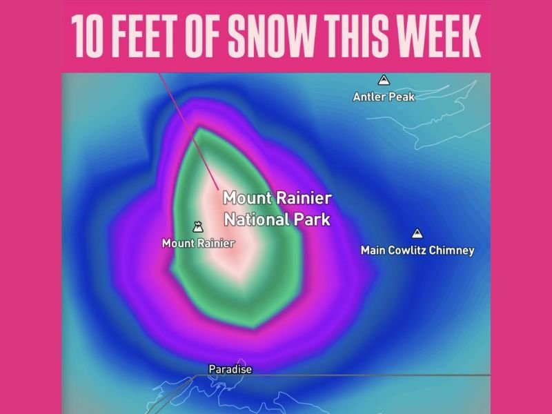
Up to 10 Feet of Snow Forecast for the Mount Rainier Summit
Meteorologists report that persistent Pacific moisture will funnel into Washington, allowing intense snowfall totals to build rapidly. The highest elevations near the summit and crater of Mount Rainier are projected to receive as much as 10 feet of snow, creating extremely hazardous conditions for climbers and backcountry travelers.
Key locations highlighted on the map include:
- Mount Rainier (Mount Tahoma) – Ground zero for the deepest snow
- Mount Rainier National Park – Widespread heavy accumulation
- Antler Peak – Significant snowfall expected
- Main Cowlitz Chimney – High-elevation snow accumulation
- Paradise – Likely to see heavy snow but lower totals than the summit
Atmospheric River Driving the Extreme Snowfall
This week’s snowfall is being fueled by another strong Atmospheric River, pushing massive amounts of Pacific moisture inland. As this moisture rises over the Cascade Range, it rapidly cools, producing intense, continuous snow at the highest elevations.
Forecasters emphasize that this setup will last several days, allowing snowfall to pile up dramatically through the week.
Travel and Safety Concerns in the Region
Although the heaviest snowfall is concentrated on the mountain itself, nearby areas at lower elevations may still experience challenging conditions, including:
- Reduced visibility
- Avalanche danger at higher slopes
- Snow-covered or icy roadways in and around Mount Rainier National Park
Visitors are strongly urged to avoid high terrain until conditions improve.
Stay updated with ongoing weather developments and regional alerts at NapervilleLocal.com.

I’ve lived in Naperville long enough to see how quickly our community changes — from new developments downtown to sudden shifts in our Midwest weather. Reporting on Naperville news and daily forecasts gives me the chance to keep neighbors informed about what really matters. My goal is simple: deliver clear, timely updates so you always know what’s happening in our city and what to expect from the skies above.