
Weather Pattern Shows Near-Record Snow Cover Across Illinois, Minnesota While Europe Faces Record-Low Snowfall Heading Into Christmas
UNITED STATES — A highly amplified winter pattern is creating a dramatic contrast across the Northern Hemisphere, with Illinois, Minnesota, Montana, and much of North America experiencing near-record snow cover, while Europe remains locked in an unusually mild pattern with record-low snowpack. Meteorologists attribute this stark divide to persistent Arctic blocking patterns, which have delivered repeated cold blasts and snowstorms to the U.S. and Canada while leaving Europe unusually warm.
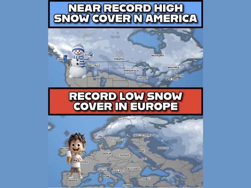
North America Buried Under Near-Record Snow Cover
The latest snow-cover graphics show a widespread blanket of snow stretching across Montana, the Dakotas, Minnesota, Wisconsin, Illinois, Michigan, and into the Northeast, placing North America “deep” into near-record snow territory for early winter.
Locations such as Great Falls, Minneapolis, Chicago, Boston, and Montreal are surrounded by expansive snowpack, reflecting the recurring Arctic air surges that have dominated the last several weeks. This pattern is consistent with the recent high-latitude blocking events that funneled cold air repeatedly into the central and eastern United States.
Meteorologists note that such amplified setups tend to produce clear “haves and have-nots,” with some regions seeing continuous winter impacts while others see none.
Europe Experiencing Record-Low Snow Cover Despite the Season
In stark contrast, Europe has slipped into record-low snow territory, with only limited snowpack across northern regions such as Scandinavia, the Alps, eastern Europe, and parts of Russia. Major European cities including London, Paris, Berlin, Warsaw, and Rome remain virtually snow-free during a period that historically sees more widespread winter coverage.
Maps highlight how even mountain regions — often reliable for snowfall — have seen far less accumulation than normal. The mild temperatures stretching across western and central Europe have kept early-winter storm systems weak and predominantly rain-producing.
This pattern is meteorologically significant, as it underscores how pronounced the atmospheric imbalance is between the two continents this winter season.
What This Pattern Means Going Into the Christmas Period
Forecasters caution that the extreme contrast between North America and Europe is likely to persist for at least the next two weeks, meaning states such as Illinois, Minnesota, Wisconsin, and Michigan may hang on to their widespread snow cover well into the holiday season.
Europe, meanwhile, is projected to see gradual but not dramatic changes, with only limited snow opportunities on the horizon. Meteorologists say it would take a major pattern flip to pull colder air into western and central Europe.
The unusual imbalance serves as a reminder that amplified weather patterns tend to feed on themselves — keeping some regions exceptionally cold and snowy while others stay stuck in prolonged warmth.
As these evolving winter patterns continue to affect both continents, stay updated with NapervilleLocal.com for ongoing climate insights, long-range winter outlooks, and regional weather impacts.

I’ve lived in Naperville long enough to see how quickly our community changes — from new developments downtown to sudden shifts in our Midwest weather. Reporting on Naperville news and daily forecasts gives me the chance to keep neighbors informed about what really matters. My goal is simple: deliver clear, timely updates so you always know what’s happening in our city and what to expect from the skies above.