
Weekend Snow and Cold Blast to Bring Chicago Its First Taste of Winter
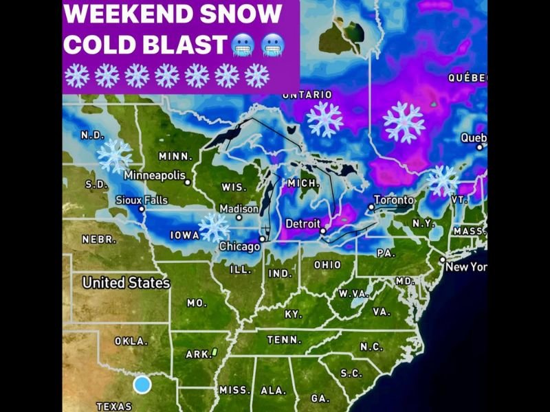
CHICAGO, ILLINOIS — Winter weather is set to make an early appearance across the Midwest this weekend, as a swath of snow and frigid air sweeps across several states — from North Dakota and South Dakota to Iowa, Illinois, and Ohio.
According to meteorologists, light to moderate snow will begin falling Saturday morning in Bismarck and Sioux Falls, spreading eastward through the day and reaching Chicago by Saturday night. The system will continue its push into Indiana and Ohio by late Sunday, accompanied by gusty winds and falling temperatures.
First Significant Snowfall for Chicago and Upper Midwest
Forecast models show the first measurable snow of the season arriving in Chicago and surrounding suburbs, with potential for wet snow accumulation as the storm center moves across the region. Behind the main low-pressure system, lake-effect snow is expected to develop around Lake Michigan, possibly bringing additional flurries into early Monday.
Residents in Iowa, Wisconsin, and Michigan could also see several inches of snow in localized areas, especially where lake-effect bands set up.
“This is shaping up to be our first widespread snow event of the season,” forecasters said. “By Sunday night, much of the Midwest will be under the influence of sharply colder air.”
Cold Air Surge and Dangerous Wind Chills
Following the snow, a massive cold front will drive frigid, dry air southward, sending temperatures plunging well below normal by Monday morning.
Wind gusts could reach 30–35 mph on Sunday, creating wind chills in the 20s across much of the Midwest and even lower in exposed areas. Meteorologists warn that the South and Southeast will also feel the impact early next week, with some areas in northern Texas and the Tennessee Valley seeing their first freeze of the season.
In Naperville and the greater Chicago metro, temperatures are expected to dip into the mid-20s Monday morning, marking one of the earliest hard freezes in recent years.
Winter Preparedness and Safety Tips
As the season’s first snowstorm approaches, residents are urged to take precautions:
- Check heating systems and space heaters before temperatures drop.
- Secure outdoor decorations or patio furniture against strong winds.
- Drive cautiously as roads may become slick with snow and ice.
- Dress in layers to protect against early winter wind chills.
Forecasters note that while this system will move out by early Monday, cold air is expected to linger through much of next week, keeping daytime highs in the 30s and low 40s across northern Illinois.
For continuous weather updates and regional forecasts, visit NapervilleLocal.com for the latest alerts and cold-weather safety coverage.

I’ve lived in Naperville long enough to see how quickly our community changes — from new developments downtown to sudden shifts in our Midwest weather. Reporting on Naperville news and daily forecasts gives me the chance to keep neighbors informed about what really matters. My goal is simple: deliver clear, timely updates so you always know what’s happening in our city and what to expect from the skies above.