
West Coast Braces for Multiple Atmospheric Rivers as Heavy Rain, Flooding, and Several Feet of Mountain Snow Expected Through Year’s End
WESTERN UNITED STATES — Meteorologists are warning of an extremely wet and stormy pattern stretching across the Pacific Northwest, California, and the Southwest over the next 10 to 14 days as multiple atmospheric rivers continue to push moisture inland. The setup is expected to bring several rounds of heavy rain, flooding concerns, and numerous feet of mountain snow, especially across the Sierra Nevada, Cascades, and Olympic Mountains.
Forecasters say this moisture-rich pattern will repeatedly impact major population centers from Seattle to San Diego, as well as interior cities across the Great Basin and Desert Southwest.
Heavy Rainfall Expected Across Major Cities
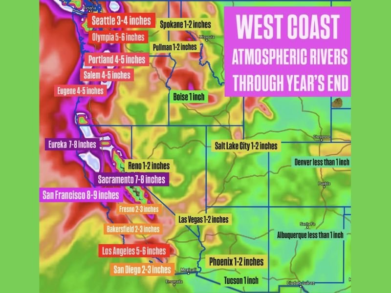
Forecast rainfall totals for coastal and valley communities include:
- Seattle: 3–4 inches
- Olympia: 5–6 inches
- Portland: 4–5 inches
- Eugene and Salem: 4–5 inches
- San Francisco: 8–9 inches
- Eureka and Sacramento: 7–8 inches
- Los Angeles: 5–6 inches
- San Diego: 2–3 inches
Interior western cities, while receiving less moisture, will still see measurable rainfall:
- Boise: ~1 inch
- Salt Lake City: 1–2 inches
- Las Vegas: 1–2 inches
- Phoenix: 1–2 inches
- Tucson: ~1 inch
This prolonged stretch of storms will significantly increase the risk of urban flooding, river rises, and stormwater overflow in areas already saturated from earlier systems.
Major Mountain Snowfall Expected
Higher elevations of the Cascades, Sierra Nevada, and Olympics may receive several feet of snow, complicating holiday travel and increasing avalanche concerns.
Upper mountain passes across Washington, Oregon, and California—including Snoqualmie Pass, Donner Pass, and Siskiyou Summit—may experience closures or chain requirements as snowfall intensifies.
Flooding, Landslides, and Burn Scar Risks
Emergency officials caution that repeated heavy rainfall will increase the likelihood of:
- Landslides and debris flows
- Flooding near rivers and creeks
- Flash flooding near recent wildfire burn scars
Communities near steep terrain and drainage channels should stay alert through the end of December.
Why Illinois Readers Should Pay Attention
Large-scale atmospheric river events often influence nationwide weather patterns, sometimes strengthening downstream systems that later affect the Midwest. Enhanced Pacific moisture can help fuel storms that reach Illinois during late December and early January. For ongoing national weather coverage and local Midwest forecasting impacts, follow NapervilleLocal.com.

I’ve lived in Naperville long enough to see how quickly our community changes — from new developments downtown to sudden shifts in our Midwest weather. Reporting on Naperville news and daily forecasts gives me the chance to keep neighbors informed about what really matters. My goal is simple: deliver clear, timely updates so you always know what’s happening in our city and what to expect from the skies above.