
West Texas Hail Threat Friday Night: Lubbock to Midland and Big Spring in Line for Ping Pong Ball Size Hail as Storms Track East Toward Wichita Falls
TEXAS — Residents across west Texas, especially from Lubbock southward toward Midland, Big Spring, and Fort Stockton, are being urged to prepare for the possibility of hail-producing storms Friday night as a maturing system develops over the region.
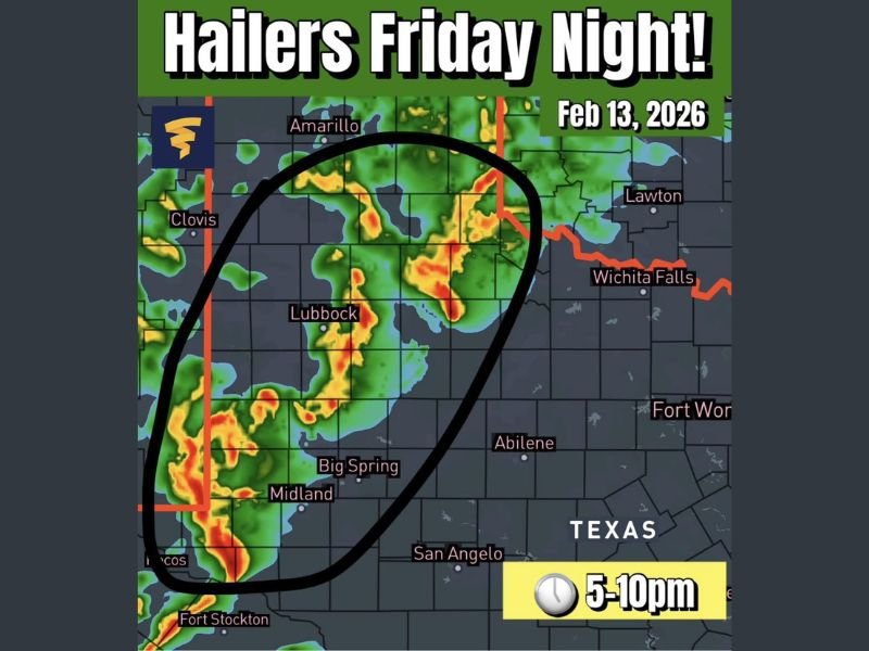
Forecast guidance indicates storms are expected to initiate by around 5 p.m. and continue for several hours into the night, with the strongest cells capable of producing hail up to ping pong ball size — approximately 1.5 inches in diameter.
Hail Risk Focused on West Texas Corridor
The primary area of concern stretches from near Clovis and Amarillo southward through Lubbock and into the Midland–Fort Stockton corridor. Big Spring is also included within the highlighted zone where the strongest storm cores are expected.
Radar projections show storms organizing in western portions of the region before tracking eastward overnight. As they move, communities east of the initial development zone — including areas toward Abilene and possibly in the direction of Wichita Falls — could see storms later in the evening.
The most intense activity is expected between:
- 5 p.m. and 10 p.m. for initial development and strengthening
- Continued eastward movement overnight
What Residents May Experience
Forecasters warn that some residents may hear “pingers” — the sound of hail striking rooftops, vehicles, and windows — as stronger storm cores pass through.
Hail up to 1.5 inches can:
- Dent vehicles
- Damage roofing and siding
- Break tree branches
- Shatter weaker windows
While the main concern highlighted is hail, strong thunderstorms can also produce gusty winds and heavy rainfall in localized areas.
Storm System Beginning to Mature
Meteorologists note that this system is expected to mature Friday evening as atmospheric conditions become more supportive of organized thunderstorms. As instability increases late in the day, stronger updrafts within storms could support larger hail formation.
The storms are projected to move generally east overnight, gradually shifting the severe potential away from the western counties and into central portions of north Texas.
Staying Prepared Friday Evening
Residents across west Texas should consider:
- Moving vehicles into garages or covered areas
- Securing outdoor items
- Monitoring local weather alerts
- Being prepared for brief periods of intense storm activity
The greatest risk window appears to center on the early to mid-evening hours, especially in and around Lubbock, Midland, Big Spring, and Fort Stockton before storms track farther east.
NapervilleLocal.com will continue monitoring developments and provide updates as new data becomes available and timing becomes more refined.

I’ve lived in Naperville long enough to see how quickly our community changes — from new developments downtown to sudden shifts in our Midwest weather. Reporting on Naperville news and daily forecasts gives me the chance to keep neighbors informed about what really matters. My goal is simple: deliver clear, timely updates so you always know what’s happening in our city and what to expect from the skies above.