
West Virginia, Tennessee, and North Carolina Track Cold Reprieve Before Major Snow and Arctic Surge Late This Week
APPALACHIAN REGION — After one of the coldest mornings of the winter so far, forecasters say a brief and misleading warm-up is underway across West Virginia, Tennessee, and North Carolina, but it will be short-lived. Updated guidance indicates snow and ice impacts arriving by the weekend, followed by a delayed but potentially stronger Arctic blast late in the forecast period.
Cold Morning Gives Way to Temporary Improvement
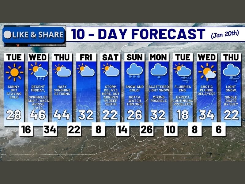
Tuesday morning brought bitter cold across West Virginia, with temperatures dropping to -1°F near Fenwick in Nicholas County and plunging to -6°F at Spruce Knob, the state’s highest elevation. Sunshine today is helping temperatures recover slightly, making conditions feel less frigid than earlier this morning. Despite the improvement, cold air remains firmly in place.
Midweek System Brings Light Snow Before Brief Quiet Period
Forecast models are tracking a weak disturbance Wednesday evening, producing scattered flurries and light sprinkles, transitioning to light snow early Thursday. Accumulations look minimal, and conditions should quiet down again afterward — but this lull is temporary.
Snow and Ice Reach I-40 in Tennessee and North Carolina by Saturday
Current trends show snow and ice reaching the Interstate 40 corridor in Tennessee and North Carolina by Saturday afternoon. Travelers are being advised to move through the region by midday Saturday at the latest, as driving conditions are expected to deteriorate rapidly afterward.
Forecast confidence is increasing that travel may become extremely difficult or impossible Saturday evening into Sunday, particularly as precipitation intensifies and temperatures continue to fall.
Potential for the Biggest Snow Event of the Season So Far
For parts of the central Appalachian region, snow may not fully arrive until Saturday night, but once it does, the system could linger through Sunday and possibly into Monday or early Tuesday. Forecasters note this setup still carries the potential to become the most significant snow event of the season so far.
Arctic Air Delayed, But Not Cancelled
While the storm’s slower progression may delay the strongest Arctic push, confidence remains high that very cold air will follow. Temperatures are projected to fall steadily through Thursday, with sub-zero readings possible region-wide by Friday morning.
This delayed Arctic surge could extend hazardous conditions well beyond the end of snowfall, increasing risks of refreezing, power strain, and prolonged travel disruptions.
What to Watch Closely
Residents across West Virginia, Tennessee, and North Carolina should prepare for:
- Rapidly worsening travel conditions this weekend
- A prolonged snow event rather than a quick hit
- A late-arriving but stronger Arctic cold surge
- Extended impacts into early next week
Forecast updates will continue as new model data comes in, but the overall signal remains clear: winter is far from finished, and the most impactful phase may still be ahead.
Are you adjusting travel plans or preparing for extended cold and snow where you live? Share your thoughts and follow ongoing weather updates on NapervilleLocal.com.

I’ve lived in Naperville long enough to see how quickly our community changes — from new developments downtown to sudden shifts in our Midwest weather. Reporting on Naperville news and daily forecasts gives me the chance to keep neighbors informed about what really matters. My goal is simple: deliver clear, timely updates so you always know what’s happening in our city and what to expect from the skies above.