
Western U.S. Forecast Shows Above-Normal Precipitation From Dec. 24–28, Raising Concerns for Holiday Travel Across Multiple States
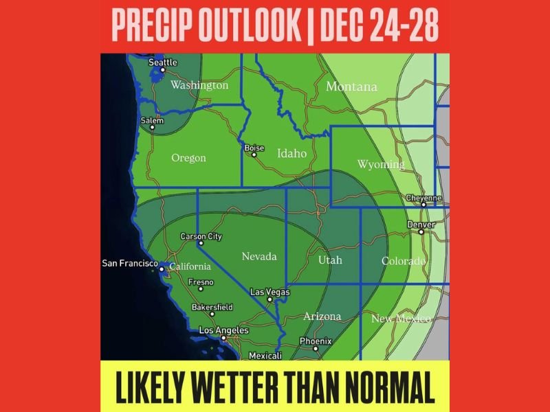
WESTERN UNITED STATES — A broad swath of the western U.S. is expected to experience above-normal precipitation from December 24 through December 28, creating potential travel disruptions during one of the busiest holiday periods of the year. Forecast maps highlight a wetter-than-average pattern affecting California, Oregon, Washington, Nevada, Idaho, Utah, Arizona, Wyoming, Montana, Colorado, and New Mexico.
Meteorologists say the setup will bring a mix of mountain snowfall, coastal rainfall, and desert moisture, depending on elevation and storm track. The pattern is typical of winter storm systems driven by Pacific moisture but poses additional risks due to the increased number of holiday travelers on roads and in airports.
Storm Pattern Expected to Impact Multiple States
Forecast models show a strong series of disturbances pushing inland from the Pacific, enhancing precipitation across much of the West. Key impacted areas include:
- Pacific Northwest: Widespread rain from Seattle to Portland, with heavy mountain snow in the Cascades
- California: Coastal and valley rain, plus Sierra Nevada snowfall that could be significant
- Intermountain West: Idaho, Nevada, Utah, and Wyoming seeing a mix of rain and snow
- Southwest: Arizona and New Mexico expected to receive more moisture than typical for late December
These conditions could produce localized flooding, slippery roads, reduced visibility, and delays at major airports including Seattle, Portland, San Francisco, Salt Lake City, Denver, and Phoenix.
Holiday Travel May Be Affected
With millions of residents traveling for Christmas weekend, transportation agencies urge early planning and flexibility. Mountain passes across the Sierra Nevada, Cascades, and Rockies may experience chain requirements, closures, or hazardous driving conditions. Meanwhile, major interstates such as I-5, I-80, and I-15 may encounter periods of heavy precipitation.
Air travel could also face delays as snow and rain impact key regional hubs. Passengers are advised to monitor airline alerts closely.
Why This Matters for Illinois and Naperville
Weather systems shaping the West often influence downstream patterns that eventually move into the Midwest. Increased moisture and storm energy in the western states can contribute to late-December storm development affecting Illinois, potentially altering temperature trends, precipitation chances, or post-holiday travel impacts.
For continued national weather updates and how major regional systems could influence the Midwest, follow NapervilleLocal.com for daily coverage.

I’ve lived in Naperville long enough to see how quickly our community changes — from new developments downtown to sudden shifts in our Midwest weather. Reporting on Naperville news and daily forecasts gives me the chance to keep neighbors informed about what really matters. My goal is simple: deliver clear, timely updates so you always know what’s happening in our city and what to expect from the skies above.