
Western U.S. Rain-and-Snow Pattern Flip: California, Oregon, Washington and the Rockies Track a Wet 2-Week Stretch With Mountain Snow Boost
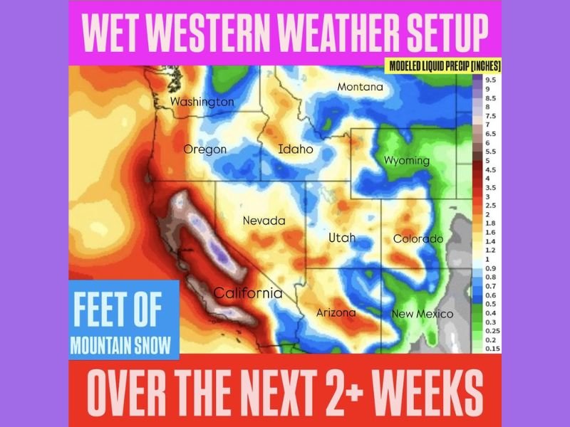
UNITED STATES — A major weather pattern change is taking aim at the Western United States, and a modeled precipitation outlook shows a widespread “wet” setup over the next 2+ weeks. The graphic points to a persistent western trough that is expected to increase moisture and lift across the region, bringing repeated rounds of rain and mountain snow and an eventual boost to snowpack — a notable shift for the West’s water-year prospects.
What the precipitation outlook is signaling for the West
The map is labeled as a modeled liquid precipitation outlook (inches) for the next couple of weeks, and the headline message is broad: the entire West is favored to see above-normal precipitation. That does not mean nonstop storms every day, but it suggests the pattern is supportive of multiple systems, with moisture repeatedly feeding into the region.
The same graphic also emphasizes “feet of mountain snow,” indicating that higher elevations — where temperatures stay cold enough — could pile up significant snowfall while lower elevations see rain.
States highlighted in the wet pattern
The outlook covers a large multi-state footprint, including:
- Washington
- Oregon
- California
- Nevada
- Idaho
- Montana
- Wyoming
- Utah
- Arizona
- Colorado
- New Mexico
In short, this is not a narrow, localized event. It’s a regional pattern that can impact coastal areas, inland valleys, and major mountain corridors across the West.
Where the heaviest precipitation looks most likely
The most intense precipitation shading is concentrated along the West Coast and California, where the map shows the highest totals in parts of:
- California’s coastal ranges and nearby mountain zones
- Portions of the Sierra Nevada region (where storm moisture often converts to heavy snow at higher elevations)
- Areas along the Pacific Northwest side of the pattern, including parts of Washington and Oregon
Farther inland, the map still indicates meaningful precipitation potential across sections of the interior West, including parts of:
- Idaho, Montana, and Wyoming
- Utah and Colorado
- Arizona and New Mexico
That inland signal often translates into a mix of valley rain and high-elevation snow depending on storm track, timing, and temperature profiles during each system.
Why a “persistent western trough” matters
A western trough is a large-scale dip in the jet stream that favors:
- Colder air aloft (helping instability and mountain snow potential)
- Repeated storm systems moving into the region
- Moisture transport from the Pacific
- Stronger lift as air rises over terrain, enhancing precipitation totals
When a trough becomes persistent, it can turn a single storm into a multi-storm stretch — the type of setup that can rebuild snowpack and improve water-year trends, but also increase the risk of travel disruptions and flooding issues in sensitive areas.
What “modeled liquid precipitation” means in real life
The map is expressed as liquid equivalent precipitation. In practice:
- At lower elevations, that liquid tends to fall as rain
- In colder mountain zones, that same moisture can translate into heavy snowfall (sometimes feet over time, especially in favored terrain)
So even if some valley totals look moderate, the same pattern can be a major snow producer in the mountains — especially when storms keep coming in waves.
Potential impacts to watch across the West
With a wet pattern covering so many states, the most likely real-world impacts include:
- Mountain travel challenges: snow-covered passes, chain controls, and slower travel on routes near major ranges
- Periodic low-elevation flooding risk: especially where heavier rain focuses along the coast or foothills
- Improved snowpack outlook: beneficial for spring runoff and long-term water supply planning
- Avalanche concerns in higher terrain: repeated loading events can raise risk quickly
- Intermittent airline delays: storms affecting West Coast hubs can ripple into connecting flights nationwide
Why this matters even for Naperville-area readers
While this is a Western U.S. setup, major West Coast and Rockies storm cycles can still matter to families in Illinois because they affect:
- National travel corridors (flight delays and cancellations often spread beyond the West)
- Supply chain timing for shipments moving through West Coast ports and rail routes
- Spring water-year headlines that influence agriculture and long-range drought or wildfire discussions later in the year
- Vacation planning, especially for families headed to mountain destinations
This is also the type of pattern change that meteorologists watch closely because it can signal whether winter and early spring will lean stormier in the West after a quieter stretch.
What to watch next as the 2-week window unfolds
Because this is a modeled outlook, the exact storm-by-storm impacts will be determined by:
- Where each individual system tracks
- How cold the air stays during each wave
- Whether storms arrive evenly or cluster in a few stronger events
The key point from the data is the broad trend: the West is entering a wetter stretch, and multiple states from California to the Rockies are positioned for more frequent precipitation and meaningful mountain snow potential over the next 2+ weeks. For more multi-state weather pattern updates explained in plain language, keep following NapervilleLocal.com.

Naperville is a community with stories that deserve to be told — both the serious ones about safety and justice, and the lighter ones that capture our culture and daily life. I focus on covering crime reports and court updates while also highlighting the traditions, events, and social trends that shape who we are. Through my reporting, I want to give readers a fuller picture of Naperville — the challenges we face and the character that keeps our city strong.