
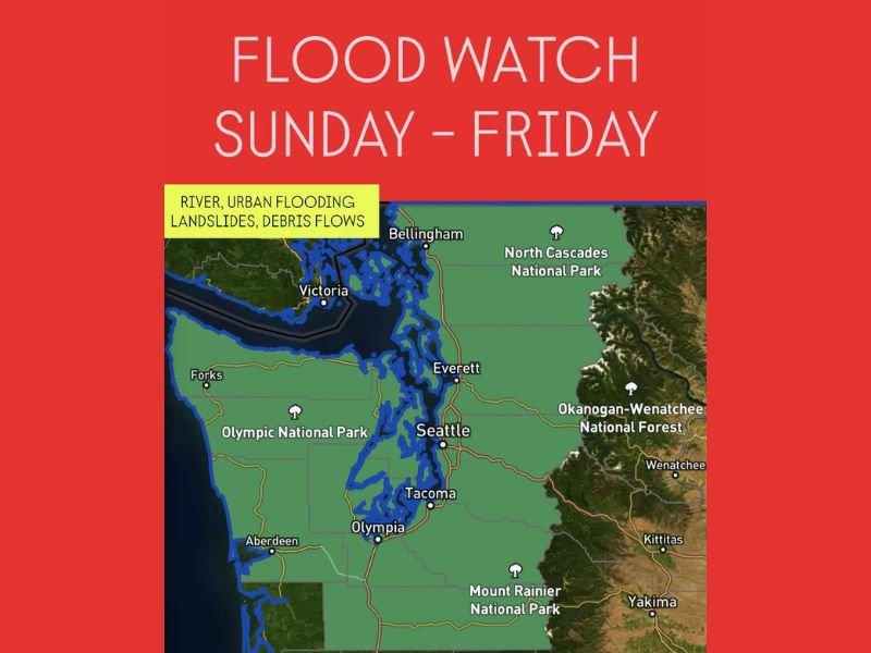
Western Washington Under Flood Watch From Sunday Through Friday as Heavy Rain Raises Threat of Landslides and Debris Flows
SEATTLE, WASHINGTON — The National Weather Service has issued a Flood Watch for western Washington beginning late Sunday and lasting through Friday afternoon, warning that a prolonged stretch of heavy rainfall could trigger river flooding, landslides, and debris flows across low-lying areas and mountain foothills. The alert includes major population centers such as Seattle, Tacoma, Everett, and Olympia, along with surrounding counties and mountain communities.
Heavy Rain Expected to Persist for Several Days
Meteorologists warn that a series of Pacific storm systems will funnel moisture into the Pacific Northwest, leading to steady and sometimes heavy rain throughout the week. Forecast models suggest that multiple inches of rain could fall across western Washington, especially near the Olympic Peninsula and the Cascade foothills, where rainfall rates will be highest.
This continuous moisture will cause rivers and streams to rise rapidly, potentially exceeding flood stage in vulnerable locations. Urban areas like Seattle and Tacoma could experience street flooding and drainage backups, while smaller creeks and low-lying neighborhoods face the risk of localized inundation. The Weather Prediction Center warns that conditions will worsen midweek as ground saturation increases, raising the likelihood of flash flooding and landslides along steep terrain.
Increased Risk of Landslides and Debris Flows
In addition to river and urban flooding, forecasters are also concerned about landslide activity and debris flows, particularly near recent burn scars from wildfires in western Washington. Intense rainfall over short periods can destabilize soil, sending rocks, mud, and vegetation down hillsides into roads and residential areas. Communities near the Olympic National Park, Mount Rainier, and North Cascades National Park should remain alert for sudden changes in terrain stability and avoid driving near steep slopes during periods of heavy rain.
Officials urge residents living near rivers or known flood zones to monitor local alerts and have an evacuation plan ready. Flooding can develop quickly in these regions, especially when combined with saturated ground and runoff from melting mountain snow.
Safety and Preparedness Measures
Emergency management agencies are encouraging residents to prepare now for extended wet conditions. Drivers should avoid flooded roadways, as even shallow water can sweep vehicles away. Those living near creeks or hillsides should clear storm drains, secure outdoor items, and keep emergency kits accessible.
Power outages are also possible due to falling trees and gusty winds accompanying the storms. Residents are urged to stay informed through local news updates, NOAA Weather Radio, or official county alert systems.
The Flood Watch is expected to remain in place through Friday afternoon, though it may be extended if additional storm systems move in. Forecasters emphasize that this week-long event represents a significant rain and flood threat for the region.
For continued updates, safety tips, and regional forecasts, visit NapervilleLocal.com for the latest information.

I’ve lived in Naperville long enough to see how quickly our community changes — from new developments downtown to sudden shifts in our Midwest weather. Reporting on Naperville news and daily forecasts gives me the chance to keep neighbors informed about what really matters. My goal is simple: deliver clear, timely updates so you always know what’s happening in our city and what to expect from the skies above.