
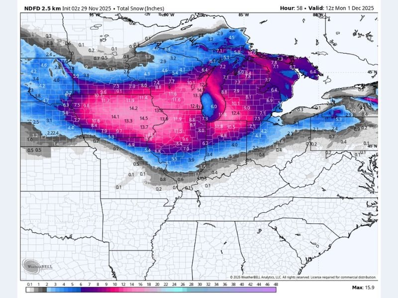
Widespread 9–15 Inches of Snow Expected Across Iowa, Illinois, Wisconsin, Indiana, and Michigan as Major Winter Storm Intensifies
MIDWEST UNITED STATES — A powerful winter storm is set to blanket much of the Midwest and Great Lakes region with 9 to 15 inches of snow through Monday morning, marking one of the most significant snow events of the season so far. Forecast models show heavy, widespread snowfall extending from Iowa and Illinois into Wisconsin, Indiana, and Michigan, with treacherous travel conditions expected to continue into early next week.
According to the National Weather Service’s latest projections, the storm system is rapidly intensifying as it moves northeast, fueled by Arctic air colliding with Gulf moisture. Snow began falling overnight across parts of Iowa and northern Illinois, and forecasters expect snowfall rates of up to 1–2 inches per hour during the storm’s peak.
Heaviest Snowfall Centered Over the Midwest
Forecast data indicates that the core of the storm will impact central Iowa through northern Illinois, southern Wisconsin, and western Michigan, where the heaviest bands of snow are expected to develop.
Cities such as Des Moines, Rockford, Milwaukee, Madison, Grand Rapids, and Chicago are likely to receive totals ranging between 10 and 14 inches, with isolated areas potentially topping 15 inches in localized lake-enhanced zones.
By Sunday evening, the storm will expand eastward into northern Indiana and lower Michigan, where additional 6–10 inches of accumulation is possible. The widespread nature of the snowfall is expected to make road conditions dangerous across multiple states.
Hazardous Travel and Blowing Snow Expected
The National Weather Service is warning residents and travelers to avoid unnecessary travel through Monday due to the risk of near-whiteout conditions, icy roads, and snow-packed interstates. Major highways including I-80, I-90, I-94, and I-35 are likely to experience slowdowns, closures, and hazardous visibility during the height of the storm.
Strong winds behind the system will also cause blowing and drifting snow, especially in open rural areas, further complicating snow removal and reducing visibility. Authorities urge drivers to keep emergency kits, extra blankets, and full fuel tanks if travel is unavoidable.
Regional Breakdown of Expected Snow Totals
- Iowa: 10–14 inches across Des Moines, Waterloo, and Cedar Rapids; up to 15 inches in the north-central region.
- Illinois: 9–13 inches from the Quad Cities through Rockford and Chicago’s north suburbs.
- Wisconsin: 10–14 inches from Madison to Milwaukee, with localized totals above 15 inches near the lake.
- Indiana: 6–10 inches across northern counties including South Bend and Fort Wayne.
- Michigan: 9–12 inches across central regions, increasing to 13–15 inches near Grand Rapids and Muskegon.
Snowfall will gradually taper off from west to east late Monday morning, but lingering flurries and gusty winds will keep visibility poor throughout the afternoon.
Cold Temperatures to Follow the Storm
Once the system moves out, bitterly cold Arctic air will settle across the Midwest. Temperatures are expected to plunge into the teens and single digits Monday night, with wind chills near or below zero in many areas.
Meteorologists warn that melting and refreezing could create slick sidewalks and icy roads through midweek, even after plows have cleared the main routes. Residents are advised to shovel early and often, as the snow’s heavy, wet consistency could pose health risks when shoveling large amounts.
Officials Urge Caution Across the Region
Emergency management agencies across affected states are urging residents to prepare now. Power crews are on standby for potential isolated outages caused by the storm’s heavy snow load on trees and power lines.
Authorities recommend checking on elderly neighbors and limiting outdoor activity until conditions improve. “This storm will bring a prolonged period of hazardous travel,” forecasters warned. “It’s best to stay home and let road crews do their work.”
Stay with NapervilleLocal.com for live updates, travel advisories, and regional coverage as this major Midwest winter storm continues through Monday.

I’ve lived in Naperville long enough to see how quickly our community changes — from new developments downtown to sudden shifts in our Midwest weather. Reporting on Naperville news and daily forecasts gives me the chance to keep neighbors informed about what really matters. My goal is simple: deliver clear, timely updates so you always know what’s happening in our city and what to expect from the skies above.