
Widespread Severe Storm Threat Building Tuesday From Texas Through Arkansas, Missouri and Illinois With Tornadoes, Large Hail, and Damaging Winds Possible
UNITED STATES — Meteorologists are warning that another significant severe weather event could develop Tuesday across a large portion of the central United States as a strengthening storm system moves through the region.
Forecast guidance shows a broad corridor of severe weather potential stretching from Texas northeast through Arkansas, Missouri, and into Illinois, where conditions may support widespread thunderstorms capable of producing damaging winds, large hail, and possible tornadoes.
The developing storm system is expected to bring a new round of active weather as severe storm season begins ramping up across the central United States.
Large Corridor of Severe Storm Potential
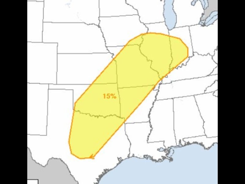
Forecast outlook maps highlight a 15 percent severe weather probability zone extending from central Texas through Arkansas and Missouri into Illinois. This risk zone represents an area where atmospheric conditions could support organized severe thunderstorms.
Meteorologists say the combination of warm, moist air from the Gulf of Mexico and strengthening upper-level winds could help storms develop rapidly during the day Tuesday. Cities across this corridor could experience strong thunderstorms as the system moves through the region.
Tornadoes, Large Hail, and Damaging Winds Possible
Forecasters say several severe weather hazards could occur within the storm zone. The primary threats include damaging straight-line winds, large hail, and the possibility of tornadoes, particularly if storms develop into rotating supercells.
Storms capable of producing hail and damaging wind gusts may also organize into clusters or lines as they move across the central United States. The exact placement of the strongest storms will depend on how the atmosphere evolves leading up to Tuesday.
Severe Weather Season Beginning to Ramp Up
Meteorologists note that this developing storm system may mark the beginning of a more active severe weather pattern as spring approaches.
Early-season storm systems often bring large temperature contrasts and strong wind patterns that can fuel severe thunderstorms across the Plains and Midwest. As warmer air continues moving northward in the coming weeks, similar storm systems may become more frequent.
Forecast Details Will Continue to Evolve
While the early outlook shows a broad severe weather zone across multiple states, forecasters say the exact areas most at risk will become clearer as the event gets closer.
Weather experts will continue monitoring atmospheric conditions over the next several days to determine where the highest threat may develop.
Residents across the central United States are encouraged to stay aware of forecast updates as meteorologists track the developing storm system expected to move through the region on Tuesday.

I’ve lived in Naperville long enough to see how quickly our community changes — from new developments downtown to sudden shifts in our Midwest weather. Reporting on Naperville news and daily forecasts gives me the chance to keep neighbors informed about what really matters. My goal is simple: deliver clear, timely updates so you always know what’s happening in our city and what to expect from the skies above.