
Wind Gusts Up to 60 MPH Slam Michigan as Temperatures Surge Into the 50s and 60° in the South — Power Outages Possible in Upper Peninsula
MICHIGAN — A dramatic late-February warmup is sweeping across the state today, bringing temperatures into the 40s and 50s statewide — and even a touch of 60 degrees in far southern Michigan — but it comes with a powerful dose of wind.
Friday marks what may be the warmest day of the weekend before temperatures tumble again Saturday and Sunday.
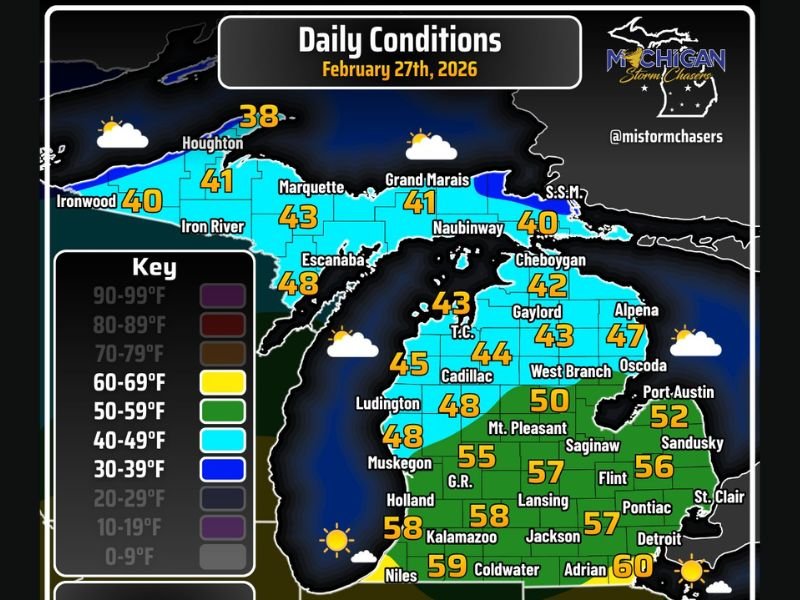
Southern Michigan Near 60°
Communities across southern Lower Michigan are enjoying the biggest temperature jump:
- Adrian: 60°
- Coldwater: 59°
- Kalamazoo: 58°
- Jackson: 58°
- Lansing: 57°
- Flint: 56°
- Pontiac: 57°
- Grand Rapids: 55°
- Muskegon: 48°
- Detroit: Upper 50s
This surge of milder air is paired with dry conditions and intervals of sunshine, making for a pleasant — albeit windy — afternoon.
Upper Peninsula Cooler, Much Windier
Conditions change significantly farther north.
Across the Upper Peninsula, highs remain in the upper 30s to upper 40s, including:
- Houghton: 38°
- Ironwood: 40°
- Marquette: 43°
- Escanaba: 48°
- Sault Ste. Marie: 40°
While the southern half of the state deals with gusty winds around 30 mph, the Upper Peninsula could see wind gusts as high as 60 mph, particularly in exposed areas.
Power outages are possible in parts of the northern U.P. due to strong gusts and downed tree limbs.
Stray Showers and Brief Lake Effect
Most of Michigan remains dry today, with partly cloudy to mostly sunny skies dominating.
However, a stray shower is possible in the “thumb” region and eastern Upper Peninsula. Later tonight, brief lake effect snow showers may develop in the eastern U.P., though they are not expected to last long.
A Short-Lived Warmup
Despite today’s springlike feel across southern Michigan, the warm conditions will not stick around. Temperatures are expected to drop back down over the weekend as the pattern resets.
Residents are advised to secure loose outdoor items, watch for flying debris, and use caution while driving — especially in higher-profile vehicles.
Friday delivers a welcome taste of warmth, but the wind is the real headline. For continued regional and national weather updates, stay connected with NapervilleLocal.com.

I’ve lived in Naperville long enough to see how quickly our community changes — from new developments downtown to sudden shifts in our Midwest weather. Reporting on Naperville news and daily forecasts gives me the chance to keep neighbors informed about what really matters. My goal is simple: deliver clear, timely updates so you always know what’s happening in our city and what to expect from the skies above.