
Winter Storm to Bring Snow, Ice and Freezing Rain Across Pennsylvania, New Jersey, Delaware, Maryland and New York on Friday
Pennsylvania — A developing winter storm is expected to impact Pennsylvania, New Jersey, Delaware, Maryland and New York on Friday, bringing a mix of snow, sleet and freezing rain that may create hazardous travel conditions through Friday afternoon and evening. Forecasters say most areas will start with snow, but many locations will transition to ice and freezing rain as the storm strengthens overnight.
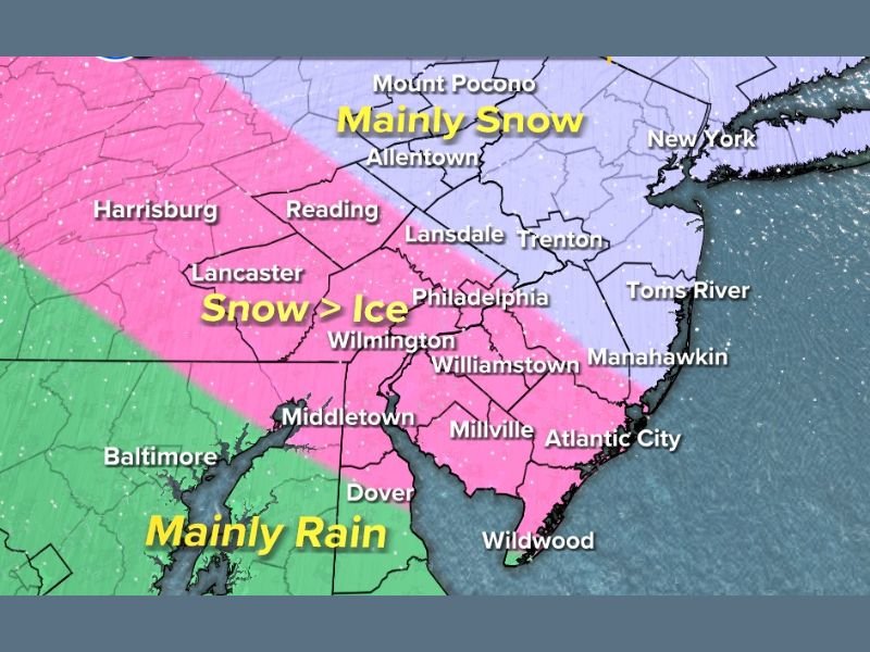
Snow Beginning Friday Afternoon Before Transition to Ice
Meteorologists report that snowfall will begin across much of the region Friday afternoon, with early accumulations likely before temperatures rise just enough to force a transition to mixed precipitation. Areas positioned farther north and west—such as Allentown, Mount Pocono and parts of northern New Jersey—are expected to remain mainly snow through the event.
These locations have a strong chance of receiving 3 inches or more of accumulation, according to early projections, with higher totals possible in colder pockets.
However, for a large portion of southeastern Pennsylvania, central and southern New Jersey and northern Delaware, the storm is expected to evolve into a snow-to-ice event. Cities including Philadelphia, Wilmington, Lancaster, Reading, Trenton and Toms River are positioned in the zone where snow will transition to sleet and freezing rain Friday night.
Significant Ice Risk for Interstate Corridors
One of the most serious concerns is the potential for freezing rain along several major highway corridors, including portions of I-95, Route 1 and the Atlantic City Expressway. The combination of initial snow followed by an icy glaze poses risks for slick road surfaces, poor visibility and sudden loss of traction during the evening commute.
Forecasters caution that even minor icing can create dangerous conditions, particularly on bridges, elevated ramps and untreated secondary roads. Areas such as Millville, Williamstown, Manahawkin and Atlantic City are expected to see more significant mixing, increasing the potential for slippery travel.
Rain Likely for Southern Maryland and Coastal Areas
Farther south, warmer temperatures will push the storm’s precipitation type toward rain. Baltimore, Dover and Middletown are expected to see predominantly rain by Friday evening, though a brief period of snow or sleet is possible at onset.
Coastal locations—including Wildwood and portions of coastal Delaware and Maryland—will largely avoid wintry accumulation but may experience periods of heavy rainfall as the system passes through.
Travel Impacts Expected Through Friday Night
Drivers across Pennsylvania, New Jersey, Delaware, Maryland and New York should expect delays, slower travel speeds and slick roadways through Friday night. With precipitation type varying sharply by location, officials urge caution for anyone traveling long distances or crossing between regions affected by different temperature profiles.
Meteorologists emphasize that the timing of the transition from snow to ice will play a major role in determining final impacts. An earlier transition could limit snow totals, while a longer period of snow may increase accumulation before the changeover.
Residents are encouraged to monitor updated forecasts and adjust travel plans if possible, especially during the evening hours when conditions may deteriorate rapidly. For continuing updates on winter weather systems, national forecasts and travel-impact information, visit NapervilleLocal.com.

I’ve lived in Naperville long enough to see how quickly our community changes — from new developments downtown to sudden shifts in our Midwest weather. Reporting on Naperville news and daily forecasts gives me the chance to keep neighbors informed about what really matters. My goal is simple: deliver clear, timely updates so you always know what’s happening in our city and what to expect from the skies above.