
Winter Storm to Bring Snow to Illinois and Indiana, Ice to Arkansas and Tennessee Early This Week
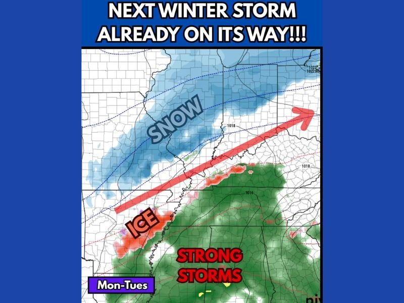
ILLINOIS — Another winter storm is taking shape and is forecast to impact Illinois, Indiana, Arkansas, and Tennessee beginning Monday, bringing a combination of snow, ice, and thunderstorms across a wide stretch of the central and southern United States.
Meteorologists say this system will be weaker than the previous storm, which dropped up to 4 inches of snow in parts of the Midwest last week, but it will still cause travel difficulties and localized hazards across multiple states.
Snow Expected Across Illinois and Indiana
Forecasters expect light to moderate snow to move into central and northern Illinois early Monday, spreading eastward into Indiana by afternoon. The system could deliver 2 to 4 inches of new snow, with locally higher totals possible in heavier bands north of Interstate 70.
While this snowfall will not rival the recent major storm, roadways could still become slick during morning and evening commutes. Cities including Springfield, Bloomington, Indianapolis, and Fort Wayne should prepare for reduced visibility and slower travel.
Ice Threat for Arkansas and Tennessee
As the system tracks east-southeast, warmer air aloft will clash with surface cold air over Arkansas and western Tennessee, leading to light freezing rain or sleet Monday night into Tuesday.
Forecasters warn that even minor ice accumulations could cause hazardous driving conditions, especially on bridges and overpasses near Little Rock, Jonesboro, and Memphis.
Authorities are advising residents to stay off the roads during the most active hours of the storm and to prepare for potential power line icing or slick walkways.
Strong Storms Possible Farther South
Farther south, in Mississippi, Alabama, and Louisiana, the same system could trigger strong to severe thunderstorms on Monday evening. While the main hazards will be heavy rain and gusty winds, forecasters aren’t ruling out isolated severe storms as temperatures surge into the 60s and 70s ahead of the front.
Travel and Safety Precautions
Drivers across the affected regions — from Chicago and Indianapolis to Little Rock and Nashville — are urged to check forecasts and road conditions before traveling.
- Allow extra time for commutes.
- Avoid unnecessary travel during icy periods.
- Keep emergency supplies such as blankets, flashlights, and phone chargers in vehicles.
Cold Air to Follow the System
Behind the storm, temperatures will drop sharply. Highs in Illinois and Indiana will stay in the upper 20s to mid-30s, while Arkansas and Tennessee will see temperatures hover near freezing by midweek.
Meteorologists expect drier weather to return by Wednesday, though another weak front may follow later in the week.
For more weather updates and regional alerts, follow NapervilleLocal.com for continuing coverage of winter systems affecting the central U.S.

I’ve lived in Naperville long enough to see how quickly our community changes — from new developments downtown to sudden shifts in our Midwest weather. Reporting on Naperville news and daily forecasts gives me the chance to keep neighbors informed about what really matters. My goal is simple: deliver clear, timely updates so you always know what’s happening in our city and what to expect from the skies above.