
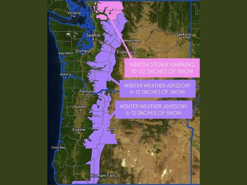
Winter Storm Warning Issued for Northern Washington Cascades as Up to 22 Inches of Snow Expected; Winter Weather Advisories Extend Through Oregon Cascades Into Early Monday
Washington & Oregon — A significant winter storm is taking shape across the Pacific Northwest as the northern Washington Cascades remain under a Winter Storm Warning through 4 a.m. Monday, with forecast totals between 12 and 22 inches of snow. Meanwhile, the central and southern Washington Cascades and the Oregon Cascades are under a Winter Weather Advisory, where 6 to 12 inches of snow are expected. Officials warn that travel over mountain passes will be difficult to hazardous as snowfall intensifies overnight.
Heavy Snow Targets Northern Washington Cascades Under Winter Storm Warning
Meteorologists say the strongest impacts will be felt in the northern Washington Cascades, where powerful Pacific moisture and colder mountain air will combine to produce over a foot of snow, with localized totals approaching two feet. Snow will fall heavily at times, reducing visibility and causing rapid accumulation on roads, particularly at higher elevations and ski resort approaches.
This is welcome news for regional ski resorts, which rely on early-season snowfall to support holiday traffic and maintain base depth. However, for travelers, the storm presents significant challenges, especially for those navigating:
- Stevens Pass
- Washington Pass
- Mount Baker region
Officials urge drivers to prepare for long delays, chain requirements, and sudden changes in road conditions.
Winter Weather Advisories for Central & Southern Washington and Oregon Cascades
Farther south, the central and southern Cascades in both Washington and Oregon will see steady and impactful snowfall totals between 6 and 12 inches. While lighter than the northern peaks, the snowfall will be enough to slow travel, especially along:
- U.S. Highway 2
- Snoqualmie Pass (I-90 corridor)
- Santiam Pass in Oregon
- Willamette Pass
Commuters and holiday travelers should expect slippery roads, increased travel times, and potential spinouts as temperatures remain cold enough for snow at pass levels.
Travel Impacts Expected Through Early Monday
With advisories and warnings extending until 4 a.m. Monday, overnight travel will be particularly hazardous. Snow showers will continue through the night before tapering Monday morning. Even after snowfall weakens, crews may require hours to clear accumulated snow and restore safe travel conditions across key passes.
Officials advise drivers to:
- Carry chains and emergency gear
- Check WSDOT and ODOT travel updates
- Avoid late-night travel if possible
- Allow extra time for mountain crossings
Outlook After the Storm
After the storm exits Monday, a brief break in precipitation is expected, though another Pacific system may approach later in the week. For continuing Pacific Northwest weather updates and national coverage, visit NapervilleLocal.com.

I’ve lived in Naperville long enough to see how quickly our community changes — from new developments downtown to sudden shifts in our Midwest weather. Reporting on Naperville news and daily forecasts gives me the chance to keep neighbors informed about what really matters. My goal is simple: deliver clear, timely updates so you always know what’s happening in our city and what to expect from the skies above.