
Winter Storm Warning Issued for Washington Cascades as 1–4 Feet of Snow Expected From Friday Through Saturday
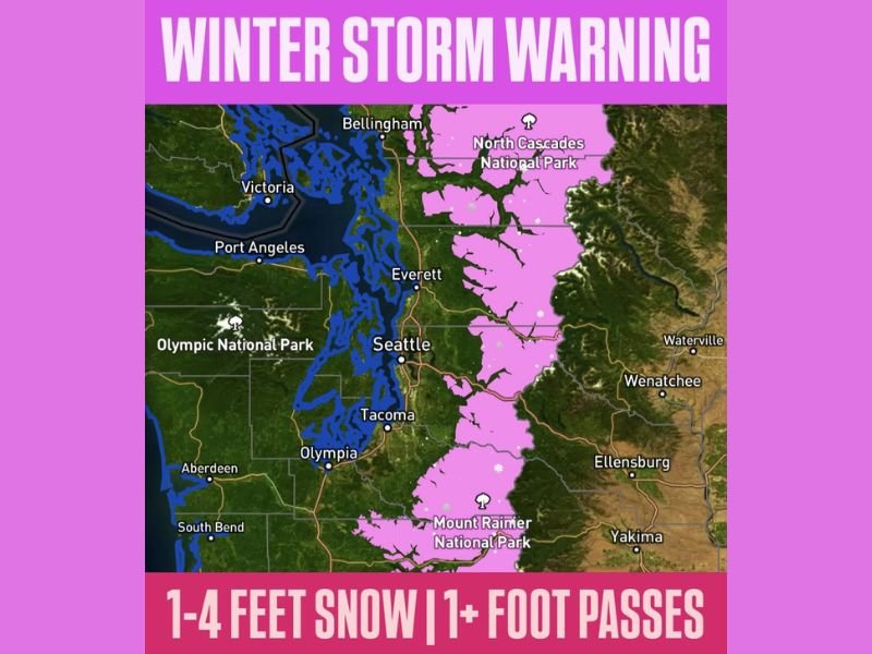
WASHINGTON — A significant Winter Storm Warning has been issued for the Washington Cascades, where forecasters expect 1 to 4 feet of snow from Friday morning through Saturday afternoon. The heaviest snowfall is projected to impact the North Cascades, Mount Rainier region, and Snoqualmie Pass, where more than a foot of accumulation is likely.
The storm system is expected to bring periods of intense snowfall, rapidly deteriorating travel conditions, and potential mountain pass closures as moisture from the Pacific meets cold air over the higher elevations.
Heavy Snowfall Targeting Major Mountain Areas
Meteorologists warn that the winter storm will deliver widespread, deep snow across the Cascades, with snow levels dropping low enough to impact several travel routes. Key expected impacts include:
- North Cascades National Park: Some of the highest totals, potentially exceeding 3 feet
- Snoqualmie Pass: Forecast to receive more than a foot of snow, causing hazardous travel
- Mount Rainier National Park: Heavy snowfall and whiteout conditions likely
- Eastern slopes near Wenatchee, Ellensburg, and Yakima: Moderate to heavy accumulations expected
The storm’s intensity may fluctuate, but forecasters emphasize that consistent snowfall over a 24–36 hour window will make travel extremely difficult across mountain corridors.
Travel Impacts and Safety Concerns
Washington’s Department of Transportation urges drivers to prepare for extended travel times, traction tire requirements, or full closures if snowfall becomes too heavy for plows to manage. Motorists should avoid mountain travel during peak storm periods unless essential.
Visibility is expected to drop sharply during heavier bursts, creating dangerous whiteout conditions. Winds in exposed mountain areas may also increase drifting and reduce visibility even further.
Residents in nearby lowland cities like Seattle, Everett, and Tacoma will not experience the extreme totals forecasted for the Cascades, but occasional rain and mixed precipitation could contribute to slick travel.
Why This Matters for Illinois Readers
Major mountain snow events in the Pacific Northwest often influence broader winter weather patterns across the U.S. As this system pushes inland, it may help shape downstream storm development that eventually affects the Midwest — including Naperville and the Chicago region — in late December.
For ongoing updates on national weather systems and their potential Midwest impacts, follow NapervilleLocal.com for reliable coverage.

I’ve lived in Naperville long enough to see how quickly our community changes — from new developments downtown to sudden shifts in our Midwest weather. Reporting on Naperville news and daily forecasts gives me the chance to keep neighbors informed about what really matters. My goal is simple: deliver clear, timely updates so you always know what’s happening in our city and what to expect from the skies above.