
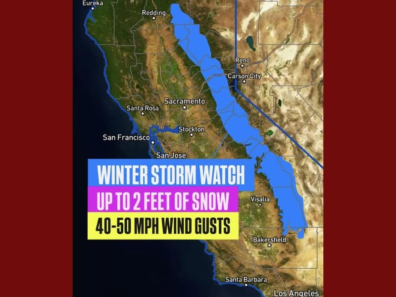
Winter Storm Watch Issued for California’s Sierra Nevada: Up to 2 Feet of Snow and 50 mph Wind Gusts Expected
SACRAMENTO — A Winter Storm Watch has been issued for the Sierra Nevada mountain range beginning Wednesday night and continuing through Thursday evening, as meteorologists warn of heavy snow and powerful winds that could make travel “extremely difficult to impossible” across higher elevations.
According to Meteorologist Chris Nunley, snowfall totals are expected to reach 6–12 inches above 5,000 feet, with localized areas above 9,000 feet possibly seeing up to 2 feet of accumulation. The storm will also bring strong wind gusts between 40 and 50 mph, creating periods of near-blizzard conditions in exposed areas.
Snow and Wind to Create Dangerous Travel Conditions
The National Weather Service warns that the combination of heavy snow and high winds could lead to whiteout conditions, downed tree limbs, and power outages in mountain communities. Drivers are urged to avoid mountain passes and prepare for chain controls or potential road closures along:
- Interstate 80 (Donner Summit)
- Highway 50 (Echo Summit)
- Highway 395 near Mammoth Lakes and Bridgeport
“Travel could become very dangerous, especially through Thursday,” Nunley said. “Blowing snow and low visibility will make driving treacherous, and near-blizzard conditions are possible at times above 7,000 feet.”
Forecast Breakdown by Elevation
- Above 9,000 feet: Up to 24 inches of snow
- 5,000–8,000 feet: 6 to 12 inches possible
- Below 5,000 feet: Light snow or rain-snow mix expected
Communities near Lake Tahoe, Truckee, Mammoth Lakes, and Yosemite’s high country are likely to experience the heaviest snowfall and strongest winds.
Timing and Peak Impacts
- Wednesday Night: Snow begins in higher elevations of Northern California, spreading southward overnight.
- Thursday Morning: Peak intensity expected, with widespread snow and strong wind gusts across the Sierra crest.
- Thursday Night: Snow begins tapering off, though lingering flurries may continue into early Friday.
Wind gusts reaching 50 mph could lead to blowing snow and drifting along ridges, reducing visibility to near zero in some areas. Temperatures will also drop sharply, with daytime highs in the 20s and 30s at higher altitudes.
Travel and Safety Tips
Officials are urging residents and travelers to prepare ahead of the storm:
- Delay non-essential mountain travel until conditions improve.
- Carry extra blankets, food, and emergency supplies if driving through affected areas.
- Secure outdoor items and check heating systems as temperatures fall.
The California Department of Transportation (Caltrans) has already begun staging snowplows and salt trucks along key passes in preparation for the storm.
Looking Ahead
Forecasters say the Sierra could see another system arrive over the weekend, potentially adding more snowfall early next week. The upcoming storm pattern marks one of the first significant winter events of the season for Northern and Central California.
Stay updated on road conditions and weather alerts at NapervilleLocal.com.

I’ve lived in Naperville long enough to see how quickly our community changes — from new developments downtown to sudden shifts in our Midwest weather. Reporting on Naperville news and daily forecasts gives me the chance to keep neighbors informed about what really matters. My goal is simple: deliver clear, timely updates so you always know what’s happening in our city and what to expect from the skies above.